Ecosystem Health Assessment in Kalimpong District (West Bengal), India Based on AHP-VORS Model
1
Department of Geography,
University of Gour Banga,
English bazaar, Malda,
West Bengal
India
2
Department of Geography,
Gour Mahavidyalaya,
Mangalbari, Malda,
West Bengal
India
Corresponding author Email: Pabanghosh398@gmail.com
Copy the following to cite this article:
Lepcha K, Ghosh P. Ecosystem Health Assessment in Kalimpong District (West Bengal), India Based on AHP-VORS Model. Curr World Environ 2024;19(3).
Copy the following to cite this URL:
Lepcha K, Ghosh P. Ecosystem Health Assessment in Kalimpong District (West Bengal), India Based on AHP-VORS Model. Curr World Environ 2024;19(3).
Citation Manager Publish History
Select type of program for download
| Endnote EndNote format (Mac & Win) | |
| Reference Manager Ris format (Win only) | |
| Procite Ris format (Win only) | |
| Medlars Format | |
| RefWorks Format RefWorks format (Mac & Win) | |
| BibTex Format BibTex format (Mac & Win) |
Article Publishing History
| Received: | 2024-09-02 |
|---|---|
| Accepted: | 2024-11-05 |
| Reviewed by: | 
 Richard Abishek S
|
| Second Review by: |

 Shrinwantu Raha
|
| Final Approval by: | Dr. S K Dash |
Introduction
Natural ecosystem in the world has been converted at unprecedented rate by a rapid increase of industrialization and urbanization and its outcome results in the degradation of ecosystem services.2-5Ascertaining the tremendous human impact on ecosystem services,6 it is necessary to detect and evaluate the impacts of anthropogenic actions on ecosystem health (EH).7-9 Ecosystem health can be defined as an ability of ecosystem that connect with the needs of society and control it quality.10, 11 Ecosystem health is extensively applied in a various areas such as forest, urban, marine and grassland habitats as a critical situation for eco-environmental development.12, 13 The concept of ecosystem health describes as acapability of ecosystem to preserve it original structures and actual functions under exotic pressure.10, 12 The topic of research on EHA and management is obtained increasing attention in nowadays because it contributes environmental management, given important function for support. But, it is true that the idea of ecosystem health is different based on mainstream and significantly accepted concept has been provided by renowned scholars.14, 15 System vigor, organization and resilience as well as absence of symbols of ecosystem anxiety and needed for healthy ecosystem propounded by a renowned scholar.14 A healthy ecosystem that can be defined as sustainable and stable for it maintains their autonomy and organization over time and resilience to stress.16 In the previous works of this topic has been done based on five parameters such as invertebrates, ecosystem process, fish, water quality and nutrient process17and used in an estuary environment, based on it that connecting with ecosystem response and pressure.18Ecosystem health is assessed based on VOR model.4, 9, and 24The continuously LULC dynamic effected the ecosystem spatial flow, function and structure tremendously which assigned substantial modifications in supply of provisioning, cultural and regulating ecosystem services.19-21The district is located in eastern Himalaya and is a major basis of eco-tourism and tourism. The encirclements of physical determinants, economic and social development in the district like the occlusion of physical resource, deterioration of environmental ecology, ecosystem degradation, soil erosion, the unconscionable outgiving of resources,the compressionof forest, backward environmental and ecological management methods.These gestures are a more important intimidation to the district for environment and ecology. Even the ecological environment of the district is further deteriorated; it will have lusty economic, social and environmental impacts on the district. So, it is needed to actual measure EH of the district and takes necessary step to sustain the EH of the district. No more study has been done in the district yet on this title. So, keeping its in mind, we have attempted to 1. Analyze the temporal and spatial changes of LULCfrom 1991 to 2021, and 2. Explore the dynamics of EH with changing LULC.
Location of Study Area
The study place is located in eastern Himalaya andextending from 88022’49’’E to 88052’35’’E and 26052’27’’N to 27011’37’’N (Fig no: 1).Highest elevation of the district is 3187 metres and lowest is 64 metres while slope of the district is ranged from 00 to 78.100. The study place is covered by 5 types of soil likeCoarse loamy, Fine loamy - Coarse loamy, Gravelly loamy, Gravelly loamy - Coarse loamy and Gravelly loamy - Loamy skeletol.1 The study place is characterized by four geomorphological units likeFluvial origin – active flood plain, Structural origin- moderately dissected hills,Fluvial origin – piedmont alluvial plain, and valleys, Structural origin- highly dissected hills and valleys as per Bhuban mapper.1 Major rivers which flow in the district are Jaldhaka, Teesta, Relliand Rangpo river.Total coverage area of thestudy place is 1053.60 km2 (105360 hectares) thatcombines 3 blocks such as Gorubathan, Kalimpong-1 and Kalimpong-2.
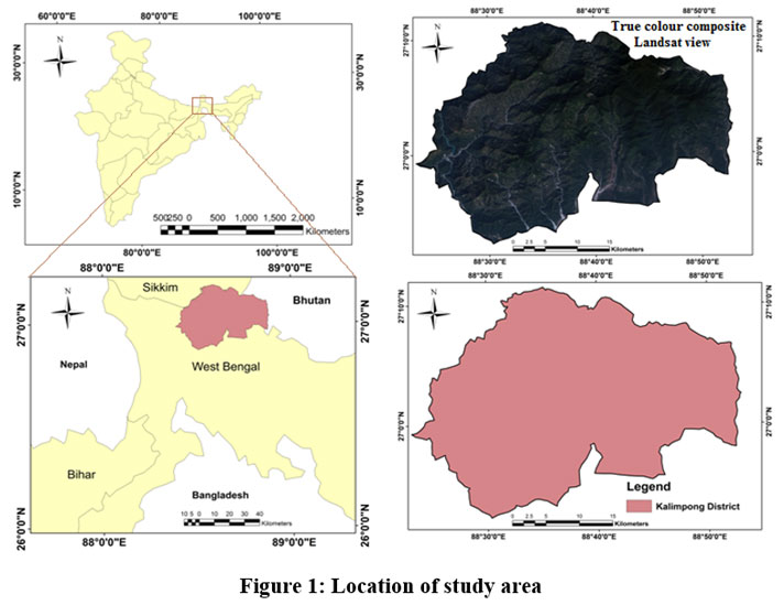 | Figure 1: Location of study area
|
Materials and Methods
Ecosystem Health Assessment Model
VORS model is used to explore the EH condition of the district. The EH condition map of the district was made by the equation no 2. The table no 1 represents the details description of VORS model parameters.Figure no 2 represents methodological framework for assessment of ecosystem health based on VORS model through AHP. Ecosystem organization parameters like Landscape heterogeneity, Landscape connectivity and Landscape shape are combined based on raster calculator with proper weight within ArcGIS 10.3 software environment (Table no: 2).
![]()
Where, HI meansEI (ecosystem health)assessment score, V means Vigor, O mean organization and R means resilience
After that, the modified equation of VORS model is as follows-
![]()
Where, S means ecosystem services.
Table 1: the details description of VORS model parameters.
Item | Factors | Indicators | Algorithm/method/software |
Ecosystem health assessment | Vigor | NDVI | Landsat satellite image and ArcGIS 10.3.1 |
Organization/fragmentation | Landscape heterogeneity: SHDI, patch density and edge density | Fragstats v4.2 software | |
Landscape connectivity: Contagion index (CONTAG) and patch cohesion index (COSION) | |||
Landscape shape: (PAFRAC) | |||
Resilience | Ecological elasticity | Eni=1?Ai * Ri where, Ai means area and Ri means score of resilience | |
Ecosystem services | Costanza et al., 1997 and 2014 coefficient | ESVt = E AK x VK where, AK means area of LULC and VK means coefficient of LULC22,23 |
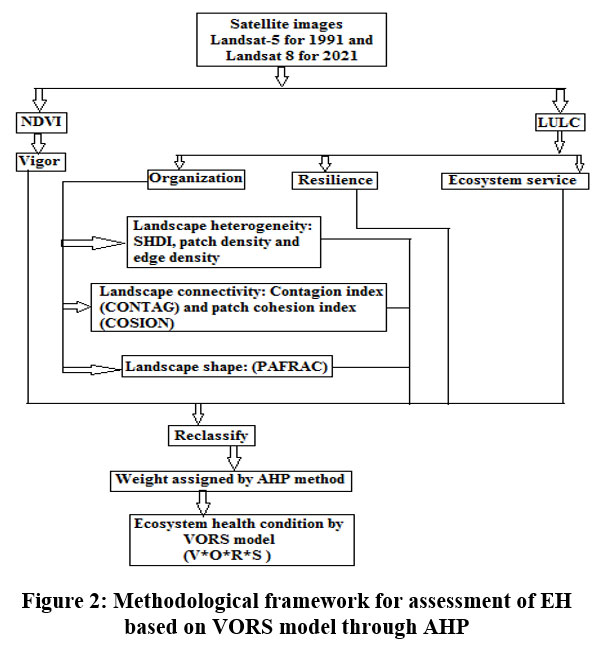 | Figure 2: Methodological framework for assessment of EH based on VORS model through AHP
|
Table 2: Weight of parameters of organization through AHP
Criterion layers | Landscape heterogeneity | Landscape connectivity | Landscape shape |
Landscape heterogeneity | 1 | 2 | 4 |
Landscape connectivity | 0.5 | 1 | 2 |
Landscape shape | 0.25 | 0.5 | 1 |
Weight assigned | 0.57 | 0.28 | 0.14 |
Consistency ratio | 0.00 | ||
Results and Discussion
LULC Classes and Measuring Ecosystem Service Value
The district is covered by7 types of LULC classes such asagriculture fallow land, forest, social forestry, agriculture plantation, build up area, agriculture land and water bodies1(fig no: 3).In 1991, maximum area of the study area was cover by forest (51.47 %) and lowest area was covered by water body (3.27 %) respectively.1 In 2021, maximum area of the study area was cover by forest (36.94 %) and lowestarea was covered by water body (4.32 %) respectively1. From the result, it is found that agriculture plantation and forest have gradually reduced and agriculture land, build up area, social forestry and agriculture fallow land have continuously increased from 1991 to 20211. Forest cover area is continuously decreased for increasing human wellbeing and human demand to fulfilled their purposes from it such as expansion of agriculture land, social forestry, construction of build up area and unplanned expansion of road network.In 1991, ESVs were ranged from 0 to 52.552 US$ million/yr and 0 to 206.089 US$ million/yr as per global CV, 1997 and 2014. In 2021, ESVs were ranged from 0 to 38.762 US$ million/yr and 0 to 147.921 US$ million/yr as per global CV, 1997 and 2014(Fig. 4).
 | Figure 3: LULC map A. 1991 and B. 2021
|
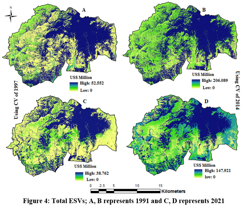 | Figure 4: Total ESVs; A,B represents 1991 and C,D represents 2021
|
Ecosystem Health Parameters
V means ecosystem vigor indicates metabolism and primary productivity of ecosystem. In this study, NDVI map is used for quantify vigor and NDVI ranged from -1 to +1. Figure no: 5 represents vegetation status of the study area. O means ecosystem organization or fragmentation which quantitatively evaluated based on three aspects such as landscape heterogeneity (SHDI, patch density and edge density), landscape connectivity (Contagion index (CONTAG) and patch cohesion index (COSION), and the landscape shape (landscape connectivity and perimeter-area fractal dimension index (PAFRAC)).Finally, landscape fragmentation map is prepared based on these three aspects using AHP model to integrate (fig no: 6 and table no: 2). R means ecosystem resilience that indicates ecosystem capacity to control its actual function. In this study, ecosystem resilience has been measuredby the coefficient of resilience of LULC and area of LULC. Fig no: 7and table no: 3 represents ecosystem resilience of the study area.
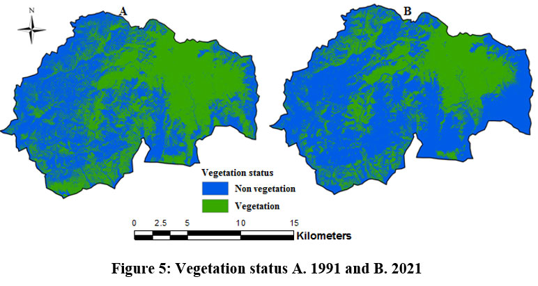 | Figure 5: Vegetation status A. 1991 and B. 2021.
|
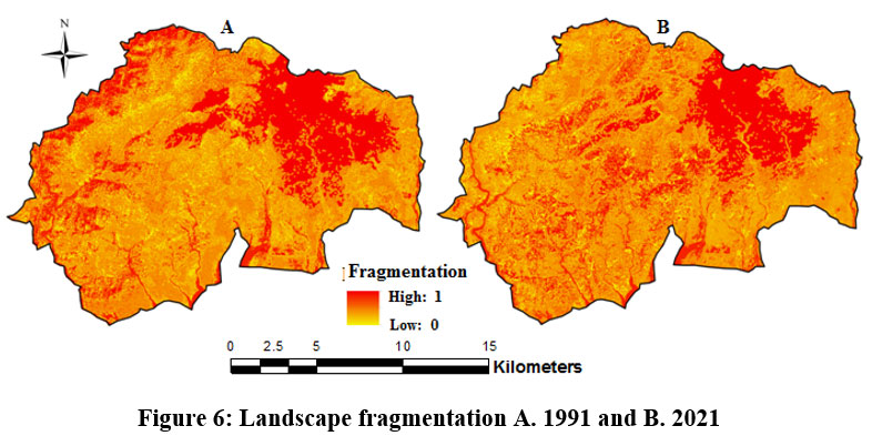 | Figure 6: Landscape fragmentation A. 1991 and B. 2021
|
Table 3: Estimation of ecosystem resilience in 1991 to 2021
LULC types | Estimation of ecosystem resilience in US$ ha-1yr-1 | |
1991 | 2021 | |
Water body | 2760.55 | 3649.08 |
Build up area | 1314.29 | 1612.67 |
Agriculture land | 5372.35 | 10624.52 |
Agriculture plantation | 6206.52 | 4736.08 |
Agriculture fallow land | 2275.24 | 3449.58 |
Social forestry | 12620.10 | 13647.64 |
Forest | 54233.90 | 38926.52 |
Total | 84782.96 | 76646.11 |
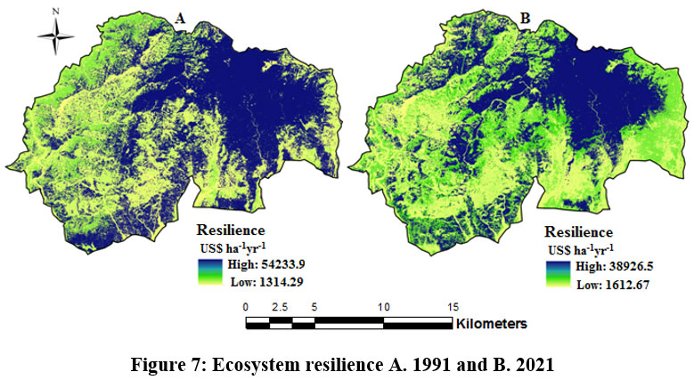 | Figure 7: Ecosystem resilience A. 1991 and B. 2021
|
Ecosystem Health Assessment byAHP-VORS Model
Finally, EH condition map of the district is categorised into five classesto identify EH conditions in 1991 to 2021(fig no: 8). The output results show that about 30.05 % and 23.30 % areas under very good health condition in 1991 are predicted while the areas under very good health conditions are changed to 22.00 % and 22.00 % in 2021 (table no: 4 and 5) as per used ecosystem services map which prepared based global CV, 1997 and 2014. In the other hand very poor ecosystem health condition area is increased from 1991 to 2021. From these findings, it can be said that alarming environmental situations and take decisions or steps to further improvement of the environmental condition of the district.
The previous works of this title has been studied based on five parameters such as invertebrates, ecosystem process, fish, water quality and nutrient process17 and applied in an estuary environment, based on it that connecting with ecosystem response and pressure.18 Ecosystem health is assessed based on VOR model.4, 9, 24 Ecosystem health is a significant component of the environment. Environmental degradation is initiated by urbanization and it causes the many terrestrial and aquatic environment losses in India.25, 26So, it is necessary to assess the EH for the protection of environment. From the discussion section, it is clear that many studies have been done on this title based on ecosystem response and pressure and another assess the ecosystem health based on VOR model. Keeping its in mind, it is declared that no studies has been done in the taken place yet now mainly based on AHP-VORS model. So, it can be concluded that it is the first work to assess the ecosystem health condition in response to LULC dynamics and it result to help the environmental planner and policy makers to take decision to further improvement of the environmental quality of the district in future.
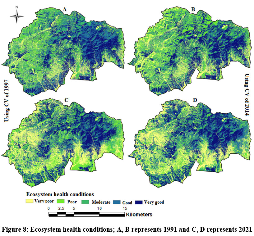 | Figure 8: Ecosystem health conditions; A,B represents 1991 and C,D represents 2021
|
Table 4: Ecosystem health conditions in 1991
Ecosystem health conditions status | Ecosystem health conditions (Area) | |||
Costanzaand his group, 1997 | Costanzaand his group, 2014 | |||
Area in hectares | Area in % | Area in hectares | Area in % | |
Very poor | 23255.26 | 22.07 | 20773.05 | 19.71 |
Poor | 14368.6 | 13.63 | 15492.38 | 14.70 |
Moderate | 3388.037 | 3.21 | 29338.68 | 27.84 |
Good | 32686.25 | 31.02 | 15201.87 | 14.42 |
Very good | 31661.86 | 30.05 | 24554.02 | 23.30 |
Total | 105360 | 100 | 105360 | 100 |
Table 5: Ecosystem health conditions in 2021
Ecosystem health conditions status | Ecosystem health conditions (Area) | |||
Costanza and his group, 1997 | Costanza and his group, 2014 | |||
Area in hectares | Area in % | Area in hectares | Area in % | |
Very poor | 25575.48 | 24.27 | 27129.98 | 25.74 |
Poor | 18181.11 | 17.25 | 11473.97 | 10.89 |
Moderate | 18367.08 | 17.43 | 18227.69 | 17.30 |
Good | 20048.07 | 19.02 | 25340.1 | 24.05 |
Very good | 23188.27 | 22.00 | 23188.27 | 22.00 |
Total | 105360 | 100 | 105360 | 100 |
Conclusion
This paper gives a depth analysis and detail description on the LULC changes from 1991 to 2021 and propounds an AHP-VORS model to assessing EH conditions of the district in the study period. The result shows forest cover area and agriculture land are continuously reducedin 1991 to 2021. ESVs of forest cover area and agriculture plantation are reduced based on global CV, 1997 and 2014.1EH map will be help local authorities and environmental scientists to take decision for effectuationof planning in several places for advancement of ecosystem health condition and provide guiding steps for protection of it and also it can be utilized for another area in future.
Acknowledgement
We are thankful to the USGS for satellite image, peoples who helped by giving valuable suggestions during our work.
Funding Sources
The author(s) received no financial support for the research, authorship, and/or publication of this article.
Conflict of Interest
The author(s) do not have any conflict of interest.
Data Availability Statement
The manuscript incorporates all datasets produced or examined throughout this research study are available on request from the corresponding author.
Ethics Statement
This research did not involve human participants, animal subjects, or any material that requires ethical approval.
Informed Consent Statement
This study did not involve human participants, and therefore, informed consent was not required
Author contributions
Kabita Lepcha: Conceptualization, Methodology, Writing – original draft, preparation, Investigation, Writing – review & editing, Supervision.
Paban Ghosh: Conceptualization, Methodology, Software, Formal analysis, Visualization, Data curation, Writing – original draft, preparation, Investigation, Writing – review & editing.
References
- Ghosh, P and Lepcha, K., Measuring the Ecosystem Services Value of Kalimpong District (West Bengal), India with Respect to Land Use Land Cover Dynamicity. Current world environment, 2024, 19 (2), 704-715
CrossRef - Long, H., Liu, Y., Hou, X., Li, T., Li, Y., Effects of land use transitions due to rapid urbanization on ecosystem services: implications for urban planning in the new developing area of China. Habitat Int., 2014, 44, 536–544.
CrossRef - Lyu, R., Zhang, J., Xu, M., Li, J., Impacts of urbanization on ecosystem services and their temporal relations: a case study in Northern Ningxia, China. Land Use Policy. 2018, 77, 163–173.
CrossRef - Xie, W., Huang, Q., He, C., Zhao, X., Projecting the impacts of urban expansion on simultaneous losses of ecosystem services: a case study in Beijing, China. Ecol. Ind. 2018, 84, 183–193.
CrossRef - Zhang, D.a., Huang, Q., He, C., Wu, J., Impacts of urban expansion on ecosystem services in the Beijing-Tianjin-Hebei urban agglomeration, China: a scenario analysis based on the Shared Socioeconomic Pathways. Resour. Conserv. Recycl., 2017, 125, 115–130.
CrossRef - Pereira, P., Ecosystem services in a changing environment. Sci. Total Environ. 2000, 702, 135008. https://doi.org/10.1016/j.scitotenv.2019.135008.
CrossRef - Qi, Y., Lian, X., Wang, H., Zhang, J., Yang, R., Dynamic mechanism between human activities and ecosystem services: a case study of Qinghai lake watershed, China. Ecol. Indic. 2020, 117, 106528. https://doi.org/10.1016/j.ecolind.2020.106528.
CrossRef - Wang, Z., Tang, L., Qiu, Q., Chen, H., Wu, T., Shao, G., Assessment of regional ecosystem health—a case study of the Golden Triangle of Southern Fujian Province, China. Int. J. Environ. Res. Public Health. 2018, 15 (4), 802.
CrossRef - Yu, G., Yu, Q., Hu, L., Zhang, S., Fu, T., Zhou, X., He, X., Liu, Yu’an, Wang, S.a., Jia, H., Ecosystem health assessment based on analysis of a land use database. Appl. Geogr., 2013, 44, 154–164.
CrossRef - Lackey, R. T. Values, policy, and ecosystem health: options for resolving the many ecological policy issues we face depend on the concept of ecosystem health, but ecosystem health is based on controversial, value-based assumptions that masquerade as science. BioScience. 2001, 51(6), 437-443. https://doi.org/10.1641/0006- 3568(2001)051[0437:VPAEH] 2.0.CO;2.
CrossRef - Rapport, D.J., what constitutes ecosystem health? Perspect. Biol. Med. 1989, 33 (1), 120–132.
CrossRef - Costanza, R. Ecosystem health and ecological engineering. Ecol. Eng., 2012 45, 24–29.
CrossRef - Xiao, R.; Liu, Y.; Fei, X.; Yu, W.; Zhang, Z.; Meng, Q. Ecosystem health assessment: A comprehensive and detailed analysis of the case study in coastal metropolitan region, eastern China. Ecol. Indic., 2019, 98, 363–376.
CrossRef - R. Costanza, toward an operational definition of health, Ecosystem Health-New Goals for Environmental Management. 1992
- D.J. Rapport, R. Costanza, A.J. McMichael. Assessing ecosystem health, Trends Ecol. Evol. 1998, 13 (10), 397–402.
CrossRef - Rapport, D.J., what constitutes ecosystem health? Perspect. Biol. Med. 1989, 33 (1), 120–132.
CrossRef - Bunn, S. E., Abal, E. G., Smith, M. J., Choy, S. C., Fellows, C. S., Harch, B. D., & Sheldon, F. Integration of science and monitoring of river ecosystem health to guide investments in catchment protection and rehabilitation. Freshwater Biology. 2010, 55, 223-240.
CrossRef - Van Niekerk, L., Adams, J.B., Bate, G.C., Forbes, A.T., Forbes, N.T., Huizinga, P., Lamberth, S.J., MacKay, C.F., Petersen, C., Taljaard, S., Weerts, S.P., Whitfield, A.K., Wooldridge, T.H., Country-wide assessment of estuary health: an approach for integrating pressures and ecosystem response in a data limited environment. Estuar. Coast. Shelf Sci. 2013, 130, 239–251.
CrossRef - Lavigne, F., Gunnell, Y., Land cover change and abrupt environmental impacts on Javan volcanoes, Indonesia: a long-term perspective on recent events. Reg. Environ. Change. 2006, 6 (1-2), 86–100.
CrossRef - Nainggolan, D., Termansen, M., Reed, M.S., Cebollero, E.D., Hubacek, K., (2013), Farmer typology, future scenarios and the implications for ecosystem service provision: a case study from south-eastern Spain. Reg. Environ. Change. 2013, 13 (3), 601–614.
CrossRef - Torres, R., Gasparri, N.I., Blendinger, P.G., Grau, H.R., Land-use and land-cover effects on regional biodiversity distribution in a subtropical dry forest: a hierarchical integrative multi-taxa study. Reg. Environ. Change. 2014, 14 (4), 1549–1561.
CrossRef - Costanza, R., d’Arge, R., De Groot, R., Farber, S., Grasso, M., Hannon, B., Limburg, K., Naeem, S., O’neill, R.V., Paruelo, J., The value of the world’s ecosystem services and natural capital. Nature,1997, pp. 253–260.
CrossRef - Costanza, R., de Groot, R., Sutton, P., Van der Ploeg, S., et al., Changes in the global value of ecosystem services. Global Environ. Change, 2014, 26, pp. 152–158.
CrossRef - Wang, Z., Liu, Y., Li, Y., 3 and Yuan Su, Y., Response of Ecosystem Health to Land Use Changes and Landscape Patterns in the Karst Mountainous Regions of Southwest China. Int. J. Environ. Res. Public Health, 2022, 19, 1-18.
CrossRef - Das, D.N., Chakraborti, S., Saha, G., Banerjee, A., Singh, D,.Analyzing the dynamic relationship of land surface temperature and landuse pattern: a city level analysis of two climatic regions in India. City Environ. Interact. 2020, 8, 100046 https://doi.org/ 10.1016/j.cacint.2020.100046.
CrossRef - Sharma, R., Joshi, P.K., Mapping environmental impacts of rapid urbanization in the National Capital Region of India using remote sensing inputs. Urban Clim., 2016, 15, 70–82.
CrossRef


