Environmental and Social Dynamics in the Land Tenure Improvement Initiative in Mbarali District, Mbeya Region, Tanzania: A Multistakeholder Perspectives
Nicholaus Fabian Mwageni
*

1
School of Engineering and Environmental Studies,
Ardhi University,
Dar es Salaam,
Tanzania
Copy the following to cite this article:
Mwageni N. F. Environmental and Social Dynamics in the Land Tenure Improvement Initiative in Mbarali District, Mbeya Region, Tanzania: A Multistakeholder Perspectives. Curr World Environ 2026;21(2).
Copy the following to cite this URL:
Mwageni N. F. Environmental and Social Dynamics in the Land Tenure Improvement Initiative in Mbarali District, Mbeya Region, Tanzania: A Multistakeholder Perspectives. Curr World Environ 2026;21(2).
Citation Manager Publish History

Introduction
Land reforms in Tanzania, like others in Sub-Saharan Africa, have decentralized land administration in rural areas, promoting land registration and titling.1Land sector has played a critical role in Tanzania’s historic trajectory of economic and social development.2However, the rapid population growth and rural-urban migration in Tanzania have led to informal land occupation, limiting investment and weakening the economy.3 In effect, the 1983 Agricultural Policy prompted the government to reform land laws and formally recognize informal settlements to support economic recovery.3The Land Act No. 4 of 1999 aligned with National Land Policy, replaced the Land Ordinance Cap 113, to support the regularization of informal settlements. The Act allows land regularization in urban and peri-urban areas to help residents secure legal land rights.4This marked a shift toward enhancing Land tenure security for those in informal settlement hence land regularization.
Land regularization in Tanzania is done in a participatory manner involving communities, with the private sector playing a key role alongside local governments and the Ministry of Lands.5,6 Communities rely on external consultants when the assistance from ministry is lacking,7fostering a sense of ownership and ensuring changes reflect community needs.8Through collaboration with local leaders and consultants, landholders gain knowledge to prioritize and negotiate land boundary changes. Formal steps, including consultations, surveys, and issuing title deeds, are set by the Ministry responsible for land.9
Land tenure regularization has boosted investment and development in Tanzania.10 Land titles have improved access to credit for income-generating activities11 and promote sustainable land use, economic growth, and poverty reduction.12Additionally, formalized land rights empower women by safeguarding their property and promoting gender equity.13
Prior, Tanzania's land regularization often lacked sufficient integration of environmental and social safeguards, leading to environmental and social risks to legal land owners.14 Addressing legal, technical, social, and environmental issues can ensure and effective and sustainable regularization process.15Thus, integrating legal, technical, environmental assessment, and social methods in land regularization enhances security and living conditions.16Participatory surveys capture these dimensions, enhancing tenure security and land management.17Thus, overlooking environmental and social factors can lead to land and water resources degradation and increased risks in sensitive areas. The authorities have neglected the legal procedures to designate hazardous areas, resulting in continued habitation in flood-prone zones.18Furthermore,there has been overlapping claims and inadequate dispute resolutionstemming from unclear institutional frameworkscontribute to persistent land conflicts in informal settlements.19
Integration of environmental and social concerns into land regularization has been strengthening the national land administration and tenure security for both genders.20The successfully integration of environmental and social considerations has promoted soil conservation practices in areas where LTIP are implemented. On another hand, the participatory approach of the land regularization process has led to increased investment in land and improved land tenure security.21
In light of this, stakeholder participation balances government interests, environmental management, and community livelihoods. Thus, it is essential for promoting equitable and successful land tenure regularization by addressing socioeconomic and environmental concerns; yet, there is currently little empirical data on multi-stakeholder responses in Tanzania. The purpose of this study was to investigate how the design and execution of the land tenure regularization process can be strengthened by effectively addressing and aligning the various viewpoints of various stakeholders through the integration of environmental and social disciplines. The study highlights the need of taking these factors into account to guarantee inclusive, sustainable, and well-coordinated outcomes among project beneficiaries by concentrating on the Land Tenure Improvement Project (LTIP) in Mbarali District, Mbeya Region, Tanzania.
Materials and Methods
Case Study Selection
This study was conducted in Mbarali District, located in the South-Western part of Tanzania, within Mbeya Region. The district has a population of 446,336 (217,280 males and 229,056 females) and 112,139 households, with an average size of 4 people. It is a semi-arid area with a unimodal rainfall pattern from November to April. The district features flat plains and part of the Usangu wetland, through which the Great Ruaha River flows. It is known for large-scale rice irrigation, agricultural crops like maize and sunflower, and livestock keeping. The district borders the Ruaha National Park, the largest in East Africa, and is intersected by key infrastructure such as roads, railways, and oil pipelines. Due to its vulnerability and public interest, Mbarali District was chosen as the ideal location to assess the environmental and social impacts of Land Tenure Improvement Initiatives from the multistakeholder perspective-balancing government interests, environmental management, and community livelihoods.
The Land Tenure Improvement (LTI) Initiatives in Mbarali District were carried out in seven townships/wards: Madibira, Ubaruku, Rujewa, Lugelele, Mabadaga, Igurusi, and Kongolo as shown in (Figure1). These townships were chosen due to their high frequency of land transactions and urban characteristics, including dense housing with informal road networks providing access as detailed in (Table 1). The area is predominantly covered by Miombo woodlands, grasses, shrubs, trees, and small bushes. Additionally, several rivers pass through or near these wards, such as the Mbarali River (Rujewa and Lugelele), Rwanyo River (Igurusi), Mswiswi River (Kongolo), and Lyandembela River (Madibira). Ponds and wetlands are also present in Madibira and Igurusi. The district is connected by key roads and reserves, with Lugelele Ward (Igawa) being adjacent to a wildlife corridor (buffer zone).
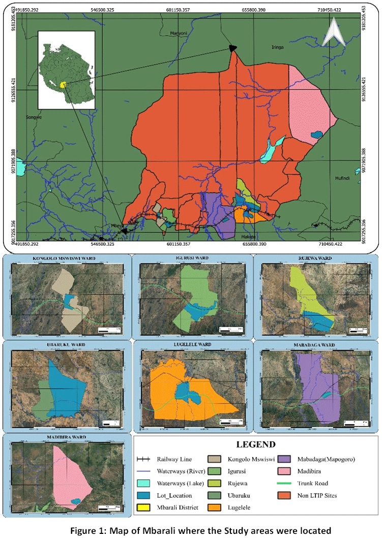 | Figure 1: Map of Mbarali where the Study areas were located
|
Table 1: Township/Wards where LTI initiatives are implemented
S/N | Townships/Wards | |||
Name | Population | Number of households | Household size | |
1 | Rujewa | 42,013 | 11058 | 3.8 |
2 | Lugelele | 15,810 | 4,358 | 3.6 |
3 | Mapogoro | 37,753 | 9,610 | 3.9 |
4 | Igurusi | 27,878 | 7,947 | 3.5 |
5 | Kongolo Mswiswi | 14,079 | 3,852 | 3.7 |
6 | Madibira | 38,120 | 9,359 | 4.1 |
7 | Ubaruku | 46,318 | 13,294 | 3.5 |
Sampling Strategy
The study aimed at capturingexperiential, institutional, and community-based insights. To ensure representation of both technical experts and affected community members, including vulnerable groups such as women and widows, the study adopted a purposive and participatory (non-probability) sampling approach to capture diverse stakeholder perspectives relevant to the Land Tenure Improvement Project (LTIP) in Mbarali District. Thus, the study employed a multi-stage, participatory sampling framework that combined extensive community interaction with deliberate selection of important informants. This strategy guaranteed thorough stakeholder participation and context-specific results pertinent to the regularization of land tenure.
Data Collection Methods
The study utilized both primary and secondary data. Primary data were collected in five stages: (1) field observations in LTIP implementation areas; (2) Key Informant Interviews with stakeholders including District Council officers (Environmental, Land, Urban Planning, Community Development, and CUCO), NEMC, TANESCO, Water Authorities, TANAPA, Rufiji Basin Water Board, OSHA, private investors, TARURA, TANROADS, TAZAM, TAZARA, TTCL, and the Ministry of Lands; (3) meetings with Ward Development Committees; (4) village-level community meetings whereby 3,391 participants attended community sensitization meetings (53.7% being men and 46.3% being women).Also, 6,792 individuals were reached through awareness campaigns whereby 48.23% were men and 51.77% being women; and (5) a validation meeting with selected participants to reflect on preliminary findings. The aim was to capture stakeholder perspectives, concerns, and suggestions. Secondary data came from reviewing key documents such as the Manual for Regularization of Unplanned Settlements, the World Bank Environmental and Social Framework, national policies, legislation, and international procedures on environmental management. Ethical considerations were observed throughout the study to ensure compliance with accepted research standards for human and institutional engagement. Although the study did not involve medical or clinical experimentation, ethical clearance principles were applied due to the involvement of human participants in interviews, focus group discussions, public meetings, and validation workshops.Prior to data collection, permission to conduct the study was obtained from relevant authorities, including the District Administration of Mbarali and participating sector institutions involved in land administration and environmental management.
Data Analysis
A mixed-methods strategy that combined quantitative and qualitative methodologies was used to analyze the data. Descriptive statistics, such as frequencies and percentages, were used to process quantitative data from stakeholder meetings, sensitization sessions, and grievance records in order to summarize participation levels, gender distribution, and the frequency of important issues like encroachment, boundary disputes, and land regularization concerns. Thematic content analysis was used to examine qualitative data from key informant interviews, focus groups, and validation meetings. Responses were classified into major themes such as infrastructure planning, gender equity, land access, and environmental preservation. To ensure consistency and dependability, triangulation was used to cross-validate results from community inputs, institutional data, and field observations.
Assessment of Environmental and Social Dynamics
The environmental and social dynamics was assessed based on how the affected parties are adjusted upon changes of ecosystem interactions among people, land, water, power, and governance infrastructures. These included the adjustment on land use to protect sensitive area and soil erosion control, buffer restoration as well as the mitigation measures in place to counteract the social changes posed by regularization. The notable changes were social compensation, participatory interventions, regular updates and sensitization meetings, land tenure disputes settlement, loss of access to resources, and addressing gender inequality in land rights).
Results
Stakeholder Feedback from the Regularization Process
The study revealed that stakeholders’ feedback on regularization process helped professionals to conduct objective, and transparent regularization process.Insights from 52 community-level sensitization sessions conducted before and during project implementation helped the team to redesign the regularization processfor better outcomes. The total number of 3,391 people attended meetings carried out in village beneficiaries whereby 1821 (54%) were men and 1570(46%) were womenimplying that both men and women as the land owners were highly motivated to have legal ownership. In other way round, widows were highly in need of the regularization process while the married womenwere interested to improve land rights ownership especially the multiple ownership option. Widowed women demonstrated a more urgent and security-driven interest in obtaining legal land rights. This is largely attributed to their heightened vulnerability following the loss of a spouse, which often exposes them to land dispossession and inheritance disputes from extended family members and limited social and economic protection mechanisms. For widows, formal land certification serves as a critical safeguard for tenure security, ensuring continued access to land for housing, livelihood activities, and intergenerational transfer.
In contrast, married women showed interest in land regularization primarily from an empowerment and co-ownership perspective. Their motivations were linked to recognition of joint ownership rights with spouses and enhancing access to credit and economic opportunities. While married women are relatively less exposed to immediate land loss compared to widows, their engagement reflects a growing awareness of the importance of formal inclusion in land ownership structures to secure long-term rights and gender equity.
These findings demonstrate that while gender disparities in land ownership persist as a structural reality, the adoption of a comprehensive, inclusive, and participatory regularization approach significantly reduces these disparities by enhancing women’s participation, strengthening tenure security for vulnerable groups, and promoting equitable land ownership practices. The distribution of attendance registration of each ward/Township per gender is presented in Figure 2.
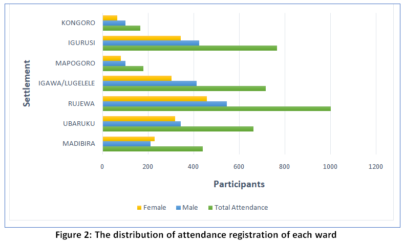 | Figure 2: The distribution of attendance registration of each ward
|
In accordance with World Bank Environmental and Social Standard (ESS10) on Stakeholder Engagement and Information Disclosure, implementers held targeted consultations with the community and utility service providers to meet social and environmental safeguard requirements. Review of these consultations’ records highlighted five overarching issues that substantiated the approach taken.
Roads Access
Stakeholders emphasized that poor or nonexistence of roads hindered access to rice fields, schools, and health centers to mention a few. During community sensitizations, people described how transportation become difficult in the rainy season, cutting them off from essential services. In response, project implementers planned for the road which would meet Space Standards for carriageways and Right of Ways and to involve communities directly in road alignment decisions to ensure functionality and ownership. Addressing road accessibility can enhance benefits of regularization. The environment for social and economic development can only happen when planning has ensured the presence of road infrastructure.This suggests that inadequate stakeholder engagement in the regularization process can hinder land allocation for road infrastructure, thereby risking continued inaccessibility of farms.
Community-Led Protection of Environmentally Sensitive Areas
By integrating GIS analyses, community feedback gathered through local leaders, and on-the-ground verification, the research team was able to pinpoint environmental sensitive areas. Stakeholder consultations particularly community reporting played a pivotal role in identifying a larger share of environmentally sensitive areas, underscoring both the community’s high level of awareness and the critical importance of local involvement. Based on these findings, 75% of the mapped sensitive zones were designated as no-build areas, 16.67% were assigned to carefully manage alternative uses and 8.33% demarcated for future development (Table 2). This implies that land regularization in environmentally sensitive areas does not depend on expert opinion only but community participation. Thus, it is vital to engage local stakeholders during land regularization process as they possess valuable environmental knowledge.
Table 2: Noted Environmental Sensitive Areas Determined During LTIP in Mbarali District
Village/Township | No. of Environmentally Sensitive Areas | Actions | ||
Prohibited | Alternative Use | Future Development | ||
Mswiswi | 1 | 1 | 0 | 0 |
Igurusi | 4 | 2 | 1 | 1 |
Mapogoro/Mabadaga | 1 | 0 | 1 | 0 |
Lugelele | 0 | 0 | 0 | 0 |
Rujewa | 2 | 2 | 0 | 0 |
Ubaruku | 1 | 1 | 0 | 0 |
Madibira | 3 | 3 | 0 | 0 |
TOTAL | 12 | 9 | 2 | 1 |
Protection of Public Utility Infrastructures
The technical inputs from utility providers particularly utility infrastructure space standards, infrastructure records, and best-practice guideline revealed that some of the plots under survey were found to be within the areas allocated for utilities.This achievement underscores how effective, well-structured stakeholder engagement can drive project success.Without first engaging the utility providers, legal property ownership provisions in these locations could result in incorrect title deed provisions, making it more difficult to revoke the deeds later. These insights enabled the safeguards team to protect and flawlessly integrate utility networks into the town plans. In effect the validation meetings were held to address any concerns and agree on mitigation measures, ensuring community needs and institutional interests were both met.
Safeguarding Land OwnershipRights and Equity
Stakeholders, especially women were concerned that land ownership formalizationmight disproportionally benefit the powerful (often men) at the expense of weak (women). It is stakeholders’ expectations that the process upholds human rights. In response to this the project ensured that the regularization team receive training in participatory mapping and respectful community engagement. In absence of safeguards implementation, the regularization could unintentionally marginalize women, widows or the poor to have equal customary land ownership.
Grievance Resolution
During community sensitizations, where residents drew on frustrations, LTIP implementers anticipated that grievances and conflicts would arise. To address this proactively, there was an established transparent grievance redress mechanism. The community were encouraged to lodge their concerns in grievance register books for prompt response. This illustrates how thorough, inclusive stakeholder engagement empowered the project team to anticipate and address community concerns. To address grievances, every plot for survey was provided with grievance register books. The grievances resolution team composed members form the Mbarali District Council, Ward office, and Village office, and the safeguard specialist from the project implementation team convened regularly to ensure fair and transparent resolutions. The register books were distributed to all 52 hamlets and overseen by each hamlet chairperson who is the head of grievance committee. The safeguard team, alongside planners and surveyors, conducted regular site visits to review and resolve entries. In total, 179 grievances from all sites were logged and resolved. The grievances were mainly based on boundaries (54.75%) followed by encroachment (21.23%) and regularization (19.55%) (Figures 3 and 4).
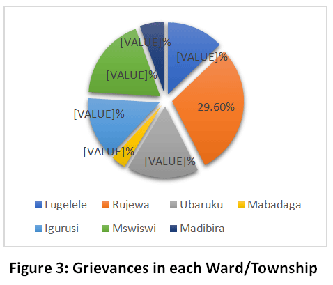 | Figure 3: Grievances in each Ward/Township
|
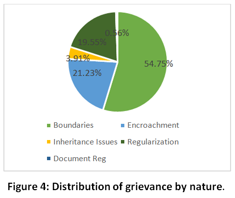 | Figure 4: Distribution of grievance by nature
|
Enhancing Planning and Sustainability through Community Insights
The studyrevealed that the engagement of the diverse stakeholders strengthened the LTIP regularization process and promoted sustainable integration of technical planning with community needs and fostering stakeholder ownership. The consultations were advantageous to both project implementers and community members.Consultations at the community level provided context-specific issues far beyond generic guidelines. Residents shared the historical behavior of sensitive areas, noting river meanders, geological shifts, and past flood events, as well as the predominant land uses in each locality. The information helped implementers to tailor the mitigation measures to address the real-world dynamics of Mbarali’s landscape rather than abstract standards.
At the institutional level, the exchange of spatial data, layout maps, GPS coordinates, and reserve space standards between project implementers and government agencies was crucial for organizing the sustainable town plan. This collaboration implies: first, some legal space standards differed from what institutions actually used, prompting the adoption of updated standards necessitating the formal legal amendments; second, for infrastructure like irrigation schemes with no formal guidelines, raw data from owners was used to define interim spatial requirements. Additionally, institutions shared plans for existing and proposed facilitiessuch as water tanks from Community Based Water Supply Organization (CBWSO) and waste collection pointswhich were integrated into the master plan to ensure sustainable service provision.
To strengthen awareness efforts, the Ministry of Lands, in collaboration with LTIP implementers, deployed 26 social experts from 9 Civil Society Organization (CSOs) across all 7 project lots. The training and sensitization meetings carried by CSOs played a key role in raising awareness about the LTIP’s goals, scope, and processes. These experts carried out sensitization through group meetings, public gatherings, and household visits, engaging various social groups. As a result, stakeholders became well-informed, actively involved and having readiness, enhancing project effectiveness and supporting long-term sustainability. Among the 6,792 people who were reached out,48.23% were men and 51.77% were women. The distribution of groups is illustrated in Figure 5. These sessions enabled stakeholders at both community and institutional levels to gain clarity, feel included, and provide meaningful cooperation throughout implementation.
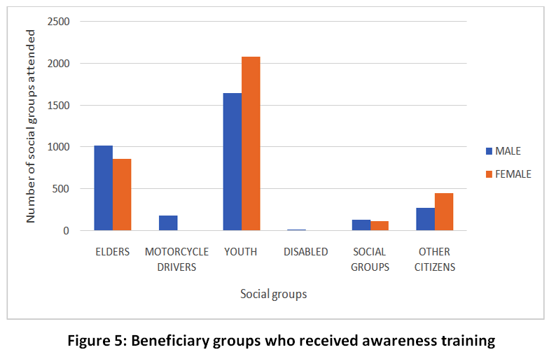 | Figure 5: Beneficiary groups who received awareness training
|
Managing Post-Regularization Risks
The study revealed that Issuing Certificates of Right of Occupancy (CROs) alone does not guarantee long-term tenure security; surveyors, planners, valuers, policy-makers, and practitioners must also ensure robust, ongoing management of environmental and social risks.
Despite detailed mitigation plans for infrastructure, such as buffer zones around sensitive areas, safeguard teams expressed concern over whether responsible institutions will implement and sustain these measures over time, especially given the tendency for natural conditions and landscape features changes. Questions arose about who will monitor compliance, how landholders will protect their newly-titled plots against evolving hazards, and whether parcels will continue to be used as intended once CROs are issued.
Field observations showed that some residents had attempted basic flood control by digging drainage channels, yet these proved inadequate during heavy rains, indicating that community-led efforts alone cannot address hazard impacts. This gap highlighted the need for the safeguard team to go beyond title issuance by providing additional support to ensure CROs remain secure and functional in the long run.
Discussion
The results indicate that by systematically incorporating stakeholder input in the LTIP, Mbarali District can markedly improve the fairness and openness of its regularization efforts. Public consultations conducted before implementing land tenure regularization programs can serve as inclusive, gender-sensitive, transparent, and participatory processes. These consultations establish a foundation for the program's execution by allowing stakeholders to voice their concerns, particularly regarding environmental and social risks. Such engagement ensures that stakeholders' perspectives are central to the program's sustainable development and can lead to participatory monitoring mechanisms.22
Ensuring thorough environmental and social safeguards is vital for elevating the voices of marginalized groupssuch as women, youth, and Indigenous Peoplesand integrating their concerns into sustainable strategies.23 Without these protections, tenure security may be at risk. Furthermore, outdated land acquisition laws that omit robust environmental and social safeguards can enable harmful development, underscoring the need for legal reforms that prioritize both ecological resilience and social equity.24
Conclusion
The study demonstrates that the Land Tenure Improvement Project in Mbarali succeeded in integrating environmental and social safeguards into its regularization process through extensive stakeholder engagement. However, a critical gap remains in ensuring that newly issued Certificates of Right of Occupancy (CROs) retain their security over the long term. To address this, it is recommended a package of post-regularization support measures, including education on utility services, training on environmental safety, highlighting economic, social, and cultural benefits of a healthy environment, and capacitating both community members and institutions, equipping them to resolve environmental and social issues with minimal risk. Further research to quantify the effectiveness in maintaining tenure security after regularization is required. Policy actions should focus on institutionalizing participatory land governance, promoting gender-responsive measures such as joint titling and protection for widows, and enforcing environmental zoning and monitoring systems. However, the study is limited by its case-specific and cross-sectional design, with potential participation bias. A follow-up longitudinal study is recommended to assess long-term impacts on tenure security, gender equity, and environmental sustainability, ensuring scalable and evidence-based land governance improvements.
Acknowledgement
I acknowledge the use of Grammarly as an AI-powered writing assistant that supported the improvement of grammar, spelling, punctuation, clarity, and tone during the writing process. I also acknowledge the valuable contribution of the Ardhi University Land Tenure Improvement Project Team for Mbarali and the Ministry of Lands, Housing and Human Settlements Development. Furthermore, I extend my sincere gratitude to Nyangi Chacha, Hussein Quraish, and Speratus Sospeter for their cooperation and support during the data collection exercise.
Funding Sources
The author(s) received no financial support for the research, authorship, and/or publication of this article.
Conflict of Interest
The authors do not have any conflict of interest.
Data Availability Statement
This statement does not apply to this article
Ethics Statement
This research did not involve human participants, animal subjects, or any material that requires ethical approval
Informed Consent Statement
This study did not involve human participants, and therefore, informed consent was not required.
Permission to reproduce material from other sources
Not Applicable
Author Contributions
The sole author was responsible for the conceptualization, methodology, data collection, analysis, writing, and final approval of the manuscript.
Reference
- Benjaminsen T.A., Bryceson I. The forgotten villages: land reform in Tanzania. Danish Institute for International Studies; 2010.https://www.files.ethz.ch/isn/134838/ The%20Forgtten %20Villages%20-%20Land%20Reform%20in%20Tanzania.pdf
- Land Portal. Tanzania: context and land governance. Published 2022.https://landportal.org
- United Republic of Tanzania (URT). National Human Settlements Development Policy, 2000. Ministry of Lands, Housing and Human Settlements Development; 2000. https://faolex.fao.org/docs/pdf/tan205478.pdf
- Boshe P. Land regularization in Tanzania: the revolution in land laws and a tool to Millennium Development Goal 7 Target 11. 2007. Open University Law Journal, 1(2), 1–14. https://ssrn.com/abstract=2358075
- Kironde JML. Community-based settlements regularization: lessons for scaling up from Makongo Juu informal settlement, Dar es Salaam, Tanzania. Curr Urban Studies, 7(2), 179–197. https://doi.org/10.4236/cus.2019.72008
CrossRef - Magigi W, Majani BBK. Community involvement in land regularization for informal settlements in Tanzania: a strategy for enhancing security of tenure in residential neighborhoods. Habitat Int. 2006. https://doi.org/10.1016/j.habitatint.2005.12.002
CrossRef - Midheme EPO. State- vs. community-led land tenure regularization in Tanzania: the case of Dar es Salaam City. Master’s thesis. International Institute for Geo-information Science and Earth Observation; 2007. https://www.semanticscholar.org/paper/State-vs.-Community-Led-Land-Tenure-Regularization-Midheme/2658f1b3f13c9748dc7ca70133c84e68c992c9fd
- Magigi W. Community involvement in informal settlements upgrading: evidence from Dar es Salaam Metropolitan City, Tanzania. Res Humanit Soc Sci. 2013. https://www.iiste.org/Journals/index.php/RHSS/article/viewFile/7117/7349
- Andreasen MH, McGranahan G, Kyessi A, Kombe W. Informal land investments and wealth accumulation in the context of regularization: case studies from Dar es Salaam and Mwanza. Environ Urban. 2020. https://doi.org/10.1177/0956247819896265
CrossRef - Msangi HA, Waized B, Löhr K, Sieber S, Ndyetabula DW. Development outcomes of land tenure formalization under customary and statutory land tenure systems in Tanzania. Agric Food Secur. 2022;11:3. https://doi.org/10.1186/s40066-022-00403-3
CrossRef - Mbilinyi JJ, Kaswamila AL, Assenga EA. Implication of land regularization in accessing credits from financial institutions in Tanzania. 2022.https://doi.org/10.4236/cus.2022.104032
CrossRef - Suzana S. Land tenure reforms and investment in Tanzania. 2013. https://www.efdinitiative.org/sites/default/files/publications/suzana-land_tenure_and_investment_in_tanzania.pdf
- DAI Global. How secure land tenure is improving lives in rural Tanzania. 2020. https://dai-global-developments.com/articles/beyond-boundaries-how-secure-land-tenure-is-improving-lives-in-rural-tanzania/
- World Bank. Environmental and Social Management Framework (ESMF) for the Land Tenure Improvement Project (LTIP). 2020. https://documents1.worldbank.org/curated/en/ 766491587412161065/pdf/Environmental-and-Social-Management-Framework-ESMF-Land-Tenure-Improvement-Project-P164906.pdf
- Fernandes E. Regularization of informal settlements in Latin America. Lincoln Institute of Land Policy; 2011. https://www.lincolninst.edu/app/uploads/legacy-files/pubfiles/regularization-informal-settlements-latin-america-full_0.pdf
- Hafsi FZ, Chabi N. Land tenure regularisation for sustainable land use in informal urban settlements. Town Reg Plan. 2019. https://doi.org/10.18820/2415-0495/trp75i1.4
CrossRef - UN-Habitat. Count me in: surveying for tenure security and urban land management. 2010. https://unhabitat.org/count-me-in-surveying-for-tenure-security
- Kironde JML. Governance deficits in dealing with the plight of dwellers of hazardous land: the case of the Msimbazi River Valley. Curr Urban Stud. 2016. https://doi.org/10.4236/cus.2016.43021
CrossRef - Sanga SA. Practitioners’ perspectives on land resource conflicts and resolution in Tanzania. J Rural Community Dev. 2019;14(2):87. https://journals.brandonu.ca/jrcd/article/ view/1665
- World Bank. Tanzania: new World Bank financing to secure land rights for up to two million citizens. 2021. https://www.worldbank.org/en/news/press-release/2021/12/21/tanzania-new-world-bank-financing-to-secure-land-rights-for-up-to-two-million-citizens
- Ali DA, Deininger K, Goldstein M. Environmental and gender impacts of land tenure regularization in Africa: pilot evidence from Rwanda. J Dev Econ. 2014; 110:262-275. https://doi.org/10.1016/j.jdeveco.2013.12.009
CrossRef - Global Land Alliance. Promoting rural land tenure security in Haiti: ensuring community participation and engagement through a tailored public consultation process. 2017. https://www.globallandalliance.org/articles /promoting-rural-land-tenure-security-in-haiti-ensuring-community-participation-and-engagement-through-a-tailored-public-consultation-process
- TMG – Think Tank for Sustainability. Land tenure and climate publication series. 2024. https://www.tmg-thinktank.com/publication-feature/land-tenure-and-climate
- Srivastav S, Singh T. Greening our laws: revising land acquisition law for coal mining in India. Econ Polit Wkly. 2022;57(46):13-16.https://doi.org/10.48550/arXiv.2304.14941
CrossRef