Evaluation of Shoreline Changes using Digital Shoreline Analysis System (DSAS) and Geospatial Techniques along coastal districts of Odisha and West Bengal, India
Mintu Jana
*
 and Dipak Bisai
1
Department of Geography,
Coastal Environmental Studies Research Center,
Egra S.S.B. College, Vidyasagar University,
Midnapore,
West Bengal
India
http://dx.doi.org/10.12944/CWE.21.1.16
Copy the following to cite this article:
Jana M, Bisai D. Evaluation of Shoreline Changes using Digital Shoreline Analysis System (DSAS) and Geospatial Techniques along coastal districts of Odisha and West Bengal, India. Curr World Environ 2026;21(1). DOI:http://dx.doi.org/10.12944/CWE.21.1.16
Copy the following to cite this URL:
Jana M, Bisai D. Evaluation of Shoreline Changes using Digital Shoreline Analysis System (DSAS) and Geospatial Techniques along coastal districts of Odisha and West Bengal, India. Curr World Environ 2026;21(1).
Download article (pdf)
Citation Manager
Publish History

Introduction
The shoreline is a critical interface between land and water, representing one of the most dynamic components of the coastal environment. It is constantly influenced by natural processes such as erosion, sediment deposition, sea-level rise, and climate change, as well as intensified anthropogenic activities. Globally, sea-level rise driven by regional climate change has emerged as a pervasive threat, directly impacting coastal morphology and shifting the equilibrium of shorelines. The dynamic nature of erosion and accretion often disrupts coastal stability, leading to significant morphological transformations. Coastal zones are routinely impacted by tidal bores, large storm surges, and other climatic uncertainties on an occasional or recurring basis. With nearly 40% of the global population inhabiting areas within 100 km of the shoreline, and roughly 10% situated below 10 meters above mean sea level (MSL), coastal zones are subject to significant anthropogenic stress.1Anthropogenic activities—such as intensive fishing, fuel wood collection, and sand mining—are highly engaged in by the local population. Given these shoreline shifts, it is essential to adopt integrated management strategies. These should prioritize systematic land-use regulation, coastal nourishment programs, and adaptive planning frameworks to mitigate the adverse effects of environmental changes in coastal regions.2Strong winds, heavy rains, and coastal storm surges all have a significant influence on shoreline alterations and coastal habitats.3Eventually, coastal processes shape the coastal beach, resources, and shoreline. However, human-induced factors—such as the construction of concrete structures, removal of coastal sand, underwater dredging, and the damming of rivers—contribute significantly to shoreline erosion.4 These disturbances are increasing the vulnerability of coastal settlements. Moreover, quantifying shoreline positions serves as a foundational element in assessing coastal vulnerability and erosion patterns, while also providing critical insights into the study of coastal morphodynamics.5 The West Bengal and Odisha coastal stretches share geomorphological similarities as part of the Bay of Bengal’s eastern shoreline, characterized by extensive deltas formed by major rivers, wide sandy beaches, and significant mangrove vegetation.6 Tropical cyclones and accompanying storm surges make these two states highly vulnerable to severe flooding. While the Odisha coast features a longer coastline and the large Chilika lagoon, the West Bengal coast is characterized by an increasing tidal range and mudflats with a diverse range of sedimentary and brackish water features.7 This study aims to quantify shoreline alterations along the coastal districts of Odisha and West Bengal from 1980 to 2025. By utilizing historical shoreline positions and standardized statistical measurements, this research seeks to provide a robust framework for coastal resource management and critical decision-making.8 The primary goal is to detect coastline changes using digital maps and multi-temporal satellite data, validated through a Cohen’s Kappa accuracy assessment to ensure scientific rigor.
Study Area
The coastal plains, beach morphology, dunes, mud-bank and estuary sedimentation are important components of the states of West Bengal and Odisha. The analysis took into account the whole 708 km of the chosen coastline, which runs the Bay of Bengal coast. It is also divided by the administrative division pursuing categorizing vulnerable coastal regions (Figure 1). Sand beaches, estuaries, dunes, mud banks, swamps, and mangrove forests are some of the features that define this region. Processes are abundant biodiversity, which includes water flora, predators, herbivores, coastal birds and a variety of marine animals. Important fishing villages that rely on coastal resources for their livelihoods may be found in all seven coastal districts. The coastal districts of South 24 Parganas, Purba Medinipur, Balasore and Kendrapara sustain a range of ecosystems, including as wetlands and mangrove forests, which are essential for the preservation of biodiversity and ecosystem services. Low-lying, level terrain, alluvial plains, coastal plains and dunes that are barely 3 to 10 meters above mean sea level are characteristics that set apart the coastal districts of Purba Medinipur and South 24 Parganas. Rising sea level and cyclonic storms, which may cause tidal floods and soil erosion, are two environmental hazards that these districts are susceptible to. Purba Medinipur and South 24 Parganas' absolute location is roughly between 21.31° N and 22.30° N latitude and 86.15° E and 88.15° E longitude. Both coastal districts are located in the Indo-Gangetic plain and the Eastern coastal plains of West Bengal. The important rivers like the Rupnarayan, Haldi, and Kansabati flow through the district. The coastal districts of Puri, Jagatsingpur, Kendrapara, Bhadrak, and Balasore in Odisha are located in the state’s eastern region in Odisha. The absolute location of the five coastal districts is 86°.3’ to 86°.45’ E longitude and 19°58’ to 20°23’ N latitude. The geomorphology of five coastal districts are characterized by a dynamic coastline with features such as lagoons, tidal flats, and mangrove swamps, shaped by tides, waves, and sediment transport. The specific river mouths like Subarnarekha, Bansgarh, and Balijohri show high erosion, and BhitarkanikaNational Park in the Kendrapara district is the second largest mangrove formation in India.
Materials and Methods
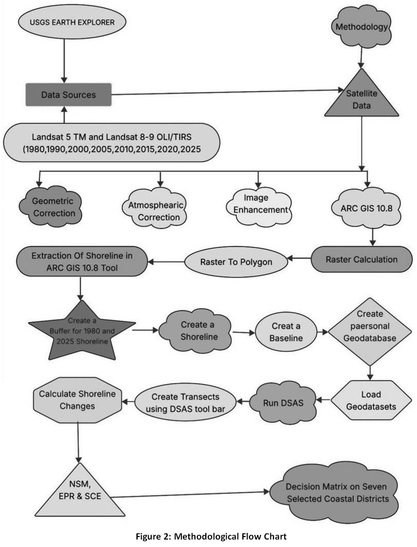
Data Sources
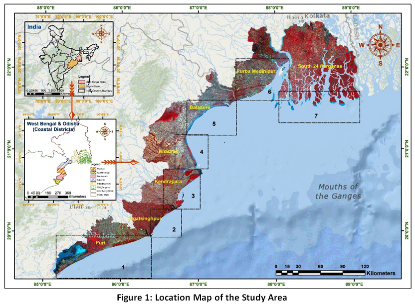 | Figure 1: - Location Map of the Study Area
|
The Landsat 5 and 8 TM OLI/TIRS type images were used to generate the MNDWI and DSAS model under RS GIS environment. The shorelines of the seven coastal districts in eastern India were traced using satellite images obtained between 1980 and 2025.To maintain uniformity across the dataset, all imagery was transformed into Top-of-Atmosphere (TOA) reflectance, followed by a cross-calibration process to harmonize spectral variations between different sensors. All satellite datasets obtained with less than 5 % cloud cover, using ArcGIS 10.8 software for atmospheric correction and image enhancement. The 45 year temporal intervals (March - May) are used to collect the data sets (Table-1), taking in to account the typical sea surface conditions throughout this time frame. All images are downloaded from the USGS EARTHEXPLORER open-source website. In the present study, advanced computational techniques like DSAS were used with the help of ArcGIS 10.8 and GOOGLE EARTH Engine Software. We have selected multi-temporal (1980-2025) imageries of Land satsensors; viz. Select coastal shoreline alterations have been identified using Thematic Mapper (MSS &TM, 1980-2025). For the purpose of observing and measuring the geophysical features of the land and sea surfaces, all land set images process synoptic and repetitive data coverage in addition to multi-spectral resolution capabilities. The WGS 84 datum and zone 45°N are fixed in the UTM projection for all downloaded satellite images.
Table 1: Satellite Image Details
Multispectral Images | Spacecraft ID | Sensor | Number of Bands | WRS Path/Row | Acquisition Date | Resolution(m) | Cloud Cover (%) | Cover Districts |
1 | Landsat 1-3 | MSS | 5 | 138/45 | 1980- | 80 | 0.65 | South 24 Parganas &Purba Medinipur |
1 | LANDSAT_9 | OLI/TIRS | 11 | 138/45 | 2025-03-27 | 30 | 0.82 | South 24 Parganas &Purba Medinipur |
2 | LANDSAT_9 | OLI/TIRS | 11 | 138/44 | 2025-03-11 | 30 | 1.08 | South 24 Parganas &Purba Medinipur |
3 | LANDSAT_8 | OLI/TIRS | 11 | 139/44 | 2025-03-26 | 30 | 0.01 | Purba Medinipur |
4 | LANDSAT_8 | OLI/TIRS | 11 | 139/45 | 2025-03-26 | 30 | 0.01 | Purba Medinipur, Balasore & Bhadrak |
5 | LANDSAT_9 | OLI/TIRS | 11 | 139/46 | 2025-05-05 | 30 | 6.09 | Bhadrak,Puri,Kendrapara &Jagatsinghpur |
6 | LANDSAT_8 | OLI/TIRS | 11 | 140/46 | 2025-05-04 | 30 | 3.84 | Puri |
 |
|
Shoreline Change Analysis
To determine the optimal threshold values, Otsu’s Automatic Thresholding method was implemented, as it effectively separates the foreground from the background by analyzing the image histogram. To analyze shoreline dynamics along the coastal stretches of Puri, Jagatsinghpur, Kendrapara, Bhadrak, Balasore, Purba Medinipur, and South 24 Parganas, an appropriate analytical procedure was implemented.Satellite images from this particular year were digitized to extract multi-dated shorelines, such as those from 1980 to 2025. In order to handle the data using ArcGIS 10.8 software, a shape file including satellite images of the chosen coastline areas was created and extracted. Subsequently, the Digital Shoreline Analysis System (DSAS) was utilized to process these shapefiles, facilitating the systematic calculation of temporal coastline fluctuations. To determine the rate of shoreline displacement, a vector- based transect model analysis of coastline changes in the seven coastal districts was conducted.9Actually, this tool helps to detect the shoreline changes depends on statistical basis.10Its performance lies on selected baseline that, fixedthe distance from the sea surface, after that, actual displacement of the shoreline detects as required years. Moreover, the shoreline was relocated in various years and the irregular coastline was constructed to an irregular baseline following the baseline fixing distance of 600 meters from the mainland. The DSAS analysis system’s run yields multiple indices.
Cohen’s Kappa Accuracy Assessment
In this investigation, we used a Geospatial Analysis approach to construct another significant accuracy system under Cohen’s Kappa Accuracy Assessment which is the expression of pixel-based Geospatial Analysis by the RS GIS methods. Measures of agreement between observed and expected agreement with correction for chance agreement are used in the accuracy evaluation through this statistical method. By taking random agreement into consideration, it computes a value that EPR(m/year)represents the quality of the classification by comparing classified data with ground truth data. A confusion matrix table is used to evaluate the extracted data.11 Better agreement is demonstratedd by a greater accuracy rating, while poor agreement is shown by a lower value. 12
Digital Shoreline Analysis System (DSAS)
The Digital Shoreline Analysis System (DSAS) is the most effective tool for assessing the shoreline. It’s a tool of software that measures the condition of the shoreline over time as an add-on to a Geographic Information System (GIS). In the DSAS model’s historical shoreline is intersected by perpendicular transects from the established baseline. 11End Point Rate (EPR (m/year)) and Net Shoreline Movement (NSM(m)), two statistical techniques used to assess erosion and accretion, provided crucial information for managing coastal zones and comprehending coastal dynamics.13
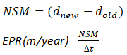
Net Shoreline Movement (NSM(M))
The NSM parameter quantifies the linear distance between the historical (oldest) and contemporary (youngest) shoreline positions, providing a spatial measure of change for every individual transect.13It calculates the total change in coastline position over the course of 45 years: erosion is demonstratedd by negative NSM (m) values, while accretion is shown by positive NSM (m) values. To delineate erosion and accretion patterns within the study area, we established a baseline utilizing 600-meter buffered intervals, from which 100-meter orthogonal transects were generated to measure shoreline displacement.The NSM (m) from 1980 to 2025 with about decadal changes in this chosen study region were identified in the current investigation.
![]()
End Point Rate (EPR(M/YEAR))
The End Point Rate (EPR), expressed in meters per year (m/year), is determined by dividing the total shoreline displacement by the elapsed time between the oldest and most recent shoreline positions. As a critical output of the DSAS model, this metric facilitates the annual quantification of coastal erosion and accretion trends derived from RS-GIS analytical frameworks.The rate of accretion is demonstratedd by a positive EPR(m/year) number, whereas the rate of shoreline erosion is shown by a negative EPR (m/year) values. The EPR(m/year) primary benefits are its simplicity of computation and its low demand of just two shoreline dates. The drawback is that when new information is provided, it is disregarded. It is possible to overlook changes in sign (i.e., accretion to erosion), magnitude, or cyclical tendencies.14
Uncertainty Estimation and Error Analysis
Determining the statistical significance of shoreline displacement rates requires rigorous quantification of positional uncertainty, a fundamental aspect of coastal morphodynamic investigations. The total positional uncertainty (U_t) for each extracted shoreline was estimated by considering various sources of error, including digitization, image resolution, and environmental factors. The cumulative uncertainty was calculated using the following root mean square (RMS) formula:
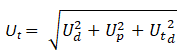
Where:
Ud(Digitization Error): Represents the human error during manual or semi-automated shoreline extraction. For this study, it was estimated based on repeated digitization of the same shoreline segments.
Up (Pixel Error): Pertains to the spatial resolution of the Landsat imagery (30 m). This is the inherent limitation of the sensor's pixel size.
Utd (Tidal Uncertainty): Accounts for the horizontal shift of the shoreline due to vertical water level fluctuations (tides) at the time of satellite overpass.
The annualized uncertainty in the shoreline change rate (Eapr) was subsequently determined as:
Where Ut1 and Ut2 are the total uncertainties for the initial and final years, and T is the time interval (45 years). Shoreline change rates (EPR) that fell within this calculated error margin were considered statistically negligible, ensuring that only significant geomorphic shifts were highlighted in the final analysis.
Shoreline Change Envelope (SCE)
The Shoreline Envelop (SCE) reports a distance (in meter) rather that a rate. The largest distance between any two shorelines that cross a specific transect is EPR(m/year) represents by the SCE value. The number for SCE is always positive since there is no sign in the total distance between two shorelines. For display purposes, the transect rate file may be cropped to this span. This approach EPR(m/year) represents the total cumulative change during the course of the study along the seven coastal regions in eastern India.
![]()
Field Survey
We have observed coastal communities and coastal resource-based results from satellite-based estimation in order to comprehend the real scenario. Along the chosen study area, field surveys have been carried out at random sites of accretion and erosion. The seven coastal districts' designated erosion points were verified on the ground and a photo was taken. Every field observation was documented in a notebook along with photographs of particular coastal areas. The results of this investigation are enhanced by the field observation and Geospatial Analysis study based on satellite images.
Results
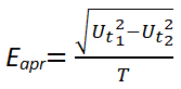
Shoreline Accuracy Assessment and Kappa Analysis
To validate the reliability of the extracted shorelines, we employed a confusion matrix alongside the Cohen’s Kappa index. The results demonstrated an overall classification accuracy of 97%, confirming the high precision of the Modified Normalized Difference Water Index (MNDWI) in distinguishing land from water across the study region. However,, the Kappa coefficients demonstrated significant regional variability, ranging from 0.14 (Purba Medinipur) to 1.00 (Kendrapara). The relatively low Kappa values in certain districts like South 24 Parganas (0.29) and Purba Medinipur are attributed to the complex geomorphology of the Sundarbans and coastal wetlands, where mixed pixels often blur the boundary between saturated soil and shallow water. Despite these "slight" to "fair" Kappa interpretations, the high overall accuracy and subsequent field verification confirm that the MNDWI-derived shorelines are reliable for long-term change detection.
By evaluating the agreement between two rates for categorical classifications and accounting for random chance agreement of RS GIS pixel values, a Cohen's Kappa accuracy assessment offers a statistical measure of inter-rater reliability. In kappa statistics, it yields positive 1 and negative 1, where 0 demonstrateds agreement that is not better than chance and +1 demonstrateds perfect agreement.15 A higher likelihood of enabling researchers to assess the consistency and dependability of our observations or classifications—which would be predicted at random—is demonstratedd when the value is larger than 0.Here, we assessed binary number selected pixels using Landsat images and working Modified Normalized Difference Water Index (MNDWI) by Cohen’s Kappa Accuracy Assessment. The RS-GIS statistical data measures the accuracy by Cohen’s Kappa Coefficient. The selected 50 to 57 points are specified on Landsat images by RS-GIS methods andthe binary selection of land and water specified to create the orbital map.
Table 2: Cohen’s Kappa Accuracy Assessment on Geospatial Analysis RS & GIS Accuracy Assessment
Sl. No | Coastal Districts | State | Area (Sq. km.) | Latitude | Longitude |
1 | South 24 Parganas | West Bengal | 9960 | 22.1367° N, | 88.5565° E |
2 | Purba Medinipur | West Bengal | 4736 | 21.9373° N | 87.7763° E |
3 | Balasore | Odisha | 3634 | 21.3469° N | 86.6611° E |
4 | Bhadrak | Odisha | 2505 | 20.9658° N | 86.6611° E |
5 | Kendrapara | Odisha | 2644 | 20.5848° N | 86.6611° E |
6 | Jagatsingpur | Odisha | 1759 | 20.1976° N | 86.3377° E |
7 | Puri | Odisha | 3479 | 19.9965° N | 85.8486° E |
Table 3: Confusion Matrix
Class | Land (0) | Water (1) | Total | |
Jagatsinghpur, Odisha | Land (0) | 45 | 1 | 46 |
Water (1) | 1 | 9 | 10 | |
Total | 46 | 10 | 56 | |
Puri, Odisha | Land (0) | 38 | 7 | 45 |
Water (1) | 0 | 5 | 5 | |
Total | 38 | 12 | 50 | |
Kendrapara, Odisha | Land (0) | 46 | 10 | 56 |
Water (1) | 0 | 0 | 0 | |
Total | 46 | 10 | 56 | |
Bhadrak, Odisha | Land (0) | 43 | 4 | 47 |
Water (1) | 4 | 6 | 10 | |
Total | 47 | 10 | 57 | |
Balasore, Odisha | Land (0) | 44 | 0 | 44 |
Water (1) | 3 | 10 | 13 | |
Total | 47 | 10 | 57 | |
Purba Medinipur, West Bengal | Land (0) | 37 | 0 | 37 |
Water (1) | 9 | 10 | 19 | |
Total | 46 | 10 | 56 | |
South 24 Parganas, West Bengal | Land (0) | 41 | 1 | 42 |
Water (1) | 4 | 9 | 13 | |
Total | 45 | 10 | 55 |
Table 4: Cohen’s Kappa Accuracy Result and its Interpretation
Study Region | Overall Accuracy (OA) | Kappa Coefficient (k) | Performance Level |
Jagatsinghpur, Odisha | 96.43\% | 0.8783 | Almost Perfect |
Puri, Odisha | 86.00\% | 0.5205 | Moderate |
Kendrapara, Odisha | 82.14\% | 0.0000 | Poor/No Agreement |
Bhadrak, Odisha | 85.96\% | 0.5149 | Moderate |
Balasore, Odisha | 94.74\% | 0.8373 | Strong |
Purba Medinipur, WB | 83.93\% | 0.5949 | Moderate |
South 24 Parganas, WB | 90.91\% | 0.7264 | Substantial |
To evaluate the classification reliability, we utilized two fundamental metrics: Overall Accuracy (OA) and the Cohen’s Kappa coefficient. Whereas OA quantifies the proportion of correctly identified pixels, the Kappa statistic offers a more rigorous validation by adjusting for the probability of agreement occurring by chance.
High Performance (Almost Perfect Agreement)
Jagatsinghpur (kappa = 0.88) and Balasore (kappa = 0.84): These regions exhibit a Kappa value > 0.81, which falls under the "Almost Perfect" category. This demonstrateds that the thresholding method was highly successful in distinguishing between 'Land' and 'Water' classes with minimal error.
Substantial Performance
South 24 Parganas (kappa = 0.73): With a Kappa value in the range of 0.61–0.80, this region shows "Substantial Agreement". The model performed reliably, though some minor misclassifications occurred between the land-water interface.
Moderate Performance
Puri (kappa = 0.52), Bhadrak (kappa = 0.51), and Purba Medinipur (kappa = 0.59): These regions fall into the "Moderate Agreement" category (0.41–0.60). Despite having relatively high Overall Accuracy (> 83%), the lower Kappa values suggest a Class Imbalance effect. The model was proficient at identifying 'Land' (the majority class) but struggled slightly with the consistent detection of 'Water' pixels.
Table 5: Kappa Ranges status
Kappa Range | Strength of Agreement | Study Regions |
< 0.00 | Poor (No Agreement) | Kendrapara |
0.00 – 0.20 | Slight | - |
0.21 – 0.40 | Fair | - |
0.41 – 0.60 | Moderate | Puri, Bhadrak, Purba Medinipur |
0.61 – 0.80 | Substantial | South 24 Parganas |
0.81 – 1.00 | Almost Perfect | Jagatsinghpur, Balasore |
 | Figure 3: Orbital Remote Sensing Map Using Landsat Images
|
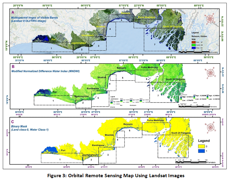
Net Shoreline Movement (NSM(M))
The Geospatial Analysis approach expresses the NSM(m) results for each of the seven coastal districts. The results of this method clearly show erosion and accretion over the 708 kilometers coastline tract; distinct colour shades identify them, with red denoting the rate of erosion for the period under consideration. The result shows that the coastal regions of the 24 Parganas districts have the highest rate of erosion, which meets 2187 meters (Figure: 3) during 1980 to 2025. However,, Purba Medinipur, Bhadrak and Kendrapara have an average shoreline change of 554 meters towards land during this period. On the other hand, the shoreline of the coastal districts of Puri, Balasore and Jagatsinghpur moves 10 meters closer to the land. The shoreline accretion is presented here by the white and blue hues, it estimates between 124 to 427 meters accretion, shifted towards ocean. After all, the NSM(M)results reveal 10 to 2187 meters shoreline shift towards land (erosion) and 10 to 227 meters coastline shift towards ocean (accretion) has been confirmed during the considered 45 years span.
District-wise Shoreline Dynamics (1980–2025)
The DSAS analysis reveals a highly dynamic coastline with distinct patterns of erosion and accretion.
South 24 Parganas: This district recorded the most extreme erosion rates, with a maximum Net Shoreline Movement (NSM(M)) of -2186.94 m over the 45-year period. This equates to an average erosion rate of approximately 48.6 m/yr. Such drastic changes are consistent with the fragile nature of the Sundarbans delta, which faces frequent cyclonic landfalls (e.g., Amphan, Yaas) and a negative sediment budget compounded by mangrove degradation.
Puri and Balasore: Interestingly, these districts demonstrated positive NSM(M) and EPR(M/YEAR) values, indicating coastal accretion (e.g., 43.25m in Balasore). While regional sea-level rise is a documented threat in the Bay of Bengal, the observed accretion in these specific pockets is likely due to localized sediment discharge from river mouths and the construction of protective coastal structures that trap longshore drift.
Table 6: EPR and NSM Rate of Different Coastal Region
Coastal Shoreline Stretch | End Point Rate (m/yr) | Net Shoreline Movement (m) |
1980-2025 | 1980-2025 | |
Puri | 0.18 | 8.41 |
Jagatsinghpur | -0.11 | -4.98 |
Kendrapara | -1.87 | -84.10 |
Bhadrak | -1.03 | -46.61 |
Balasore | 0.96 | 43.25 |
Purba Medinipur | -0.01 | -0.32 |
South 24 Parganas | -3.90 | -175.57 |
Statistical Interpretation and Uncertainty
The use of the End Point Rate (EPR(M/YEAR)) provided a clear snapshot of the cumulative 45-year shift. Although EPR(M/YEAR) ignores intermediate fluctuations, it effectively highlights the net vulnerability of the coast. To mitigate errors arising from varying Landsat sensor resolutions (MSS vs. OLI), all data were radiometrically normalized and projected to a uniform grid (UTM Zone 45N). The Shoreline Change Envelope (SCE) values reached up to 2187 m, emphasizing the high mobility of the deltaic shorelines. The "noisy" data points observed in mangrove-dense transects were statistically addressed by incorporating a positional uncertainty buffer in the DSAS model, ensuring that the reported rates reflect actual geomorphic change rather than sensor artifacts.
Comparison with Global and Regional Studies
Our findings corroborate recent studies in the Bay of Bengal (e.g., Sreeraj et al., 2022), which emphasize how the synergistic effects of eustatic sea-level rise and tectonic subsidence collectively drive geomorphological transformations within the Bengal Delta.The extreme erosion in the West Bengal sector versus the relative stability or accretion in parts of the Odisha coast underscores the role of local hydrodynamic conditions and sediment supply in modulating the effects of global climate change.
Comparison with Global and Regional Studies
Our observations are consistent with existing literature concerning the Bay of Bengal,2 specifically regarding the combined influence of eustatic sea-level rise and tectonic subsidence on the Bengal Delta. Furthermore, the stark contrast between the significant erosional trends observed along the West Bengal coastline and the relative geomorphological stability—or occasional accretion—in various segments of the Odisha coast, highlights the critical role of local hydrodynamic factors and sediment availability in mediating global climatic impacts.
End Point Rate (EPR(m/year))
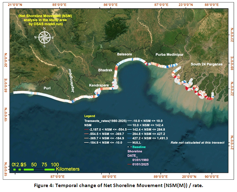
The End Point Rate (EPR(m/year)), which is particularly related to the mode of sedimentation and includes erosion for negative values and accretion for positive values, is also used to quantify shoreline changes characteristics. As per principal of the DSAS (Digital Shoreline Analysis System) model, the red colour is indicating maximum erosion rate/ year. Maximum rate of erosion has been identified under the coastal tract of South 24 Pargana and for Purba Medinipur district. The calculated rate of erosion for, I mean End Point Rate (EPR(m/year)) is -3.90 meters per year for South 24 Pargana coastline, shown in Table 4 & 5 and Figure4.Significant erosion rates are shown at Jagatsingpur, Kendrapara and Bhadrak, where annual End Point Rate (EPR(M/YEAR)) are -0.11, -1.87, and -1.03 respectively. Conversely, coastal segments within Puri and Balasore districts demonstrate positive End Point Rate (EPR) values of 0.18 m/year and 0.96 m/year, respectively. These positive trends signify a sustained accretionary environment throughout the study period. These beaches’ morphological stability over the past few decades is also supported by the physical verification and that have Net Shoreline Movement (NSM(m)) of 8.41 and 43.25 meters respectively. These two beaches’ structural infrastructure seems to be steadily accelerating the pace of silt accumulation by ± 2 and ±3 annually (Table 5).
 | Figure 4: Temporal change of Net Shoreline Movement (NSM(M)) / rate.
|
 | Figure 5: Temporal change of End Point Rate (EPP)
|
Erosion Trends (m/year) of Different Coastal Stretches
When we investigate the grid wise results of the area under consideration, Figure 6, illustrates both stability and instability. While grids 1, 2, 3 and 4 exhibit nearly steady conditions, grids 5, 6, and 7 show significant changes, including erosion. Images from 1980 to 2025 show that the South 24 Pargana and Purba Medinipur beaches are silt-dominated area with significant erosion. This coastal region is routinely affected by multiple cyclones each year. It is also taken into account that fluctuations in the water level may cause the shoreline to shift over time. In the coastal areas of 24 Parganas, erosion and accretion are interdependent processes, through which the coastal natural environment remains constantly changing yet maintains a state of equilibrium. That type of situation does not demonstrateds long term linear changes towards a single direction. So, the propagation of the beach and shoreline shift only happen due to possible depending fluctuation factors. Natural such causes, like repeated cyclone hits, sea level fluctuation, salinity differentiations, balanced siltation rolling, absence of mangrove extension etc. are also related to that. Some anthropogenic activities also directly affected the silt propagation process thereof. Coastal transect of South 24 Pargans, and Purba Medinipur are considered now the most vulnerable zones under the study area. Following the implementation of the DSAS(Digital Shoreline Analysis System) model, the south face of Fraserjang and Henry Island has consistently shown the erosion tendency. Similarly, coast of Purba Medinipur also exhibit as same situation. However,, other transects beneath the coasts of Bhadrak and Balasore show an erosion trend in a few isolated areas. All these kinds of situation are shown in Figure 6 &Table 6.
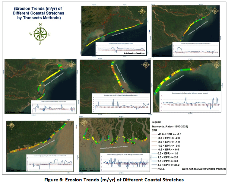 | Figure 6: Erosion Trends (m/yr) of Different Coastal Stretches
|
Table 7: Coastal Shoreline Erosion and Accretion Rate/year (CLr)
Sl. No. | District | State | Maximum (+&-) | Minimum (+&-) | Mean | Standard Deviation (SD) |
1 | South 24 Parganas | West Bengal | +1393.22 | -2186.94 | -175.567 | 408.98 |
2 | Purba Medinipur | West Bengal | +880.3 | -1122.97 | -0.32 | 349.06 |
3 | Balasore | Odisha | +1455.47 | -1424.16 | +43.25 | 364.16 |
4 | Bhadrak | Odisha | +1482.15 | -914.51 | -46.61 | 279.67 |
5 | Kendrapara | Odisha | +1491.21 | -1184.71 | -84.10 | 371.82 |
6 | Jagatsinghpur | Odisha | +1254.58 | -886.42 | -4.98 | 369.63 |
7 | Puri | Odisha | +286.13 | -503.72 | 8.41 | 83.11 |
The statistical framework yields a detailed assessment of the spatial heterogeneity and the scale of shoreline migration throughout the study area. By examining key descriptors—including Maximum, Minimum, Mean, and Standard Deviation (SD)—we can effectively quantify the intensity of coastal erosional and accretional processes.
Extreme Displacement (Maximum and Minimum Values)
The data reveals significant coastal dynamics across almost all districts.
Highest Accretion/Landward Shift:Kendrapara (+1491.21) and Bhadrak (+1482.15) recorded the highest positive displacement, indicating significant deposition or seaward advancement in certain sections.
Highest Erosion/Seaward Shift:South 24 Parganas experienced the most extreme negative displacement (-2186.94), suggesting severe localized erosion or land loss compared to other districts.
Average Shoreline Trend (Mean Displacement)
The Mean value demonstrated the overall net trend of the district's shoreline.
Dominant Erosion:South 24 Parganas (-175.567) and Kendrapara (-84.10) show a strong negative mean, suggesting that, on average, these coastlines are undergoing a net erosional trend.
Near-Stability:In contrast, Purba Medinipur (-0.32) and Jagatsinghpur (-4.98) exhibit mean values proximal to zero, suggesting a near-equilibrium state where erosional and accretional processes are largely balanced along the district's coastline.
Net Accretion:Balasore (+43.25) and Puri (+8.41) are the only regions showing a net positive mean, indicating a general trend of shoreline advancement.
Variability and Stability (Standard Deviation)
The Standard Deviation (SD) reflects how much the shoreline change varies along the coast.
High Volatility:South 24 Parganas (408.98) has the highest SD, indicating that the shoreline changes are highly inconsistent, with some areas eroding heavily while others may be stable.
Relative Stability:Puri (83.11) shows the lowest SD and the smallest range between Max and Min. This suggests that the shoreline in Puri is significantly more stable and uniform compared to the highly dynamic coasts of Odisha and West Bengal.
Shoreline Change Envelope (SCE)
Shoreline Change Envelope (SCE) is statistical techniques provide information on how much the shoreline has changes from the baseline. Baseline has been fixed at 600 meter from the mean shoreline for this study. The general observation was determined for the whole considered area, which are separates in seven consecutive transects. Fast and massive erosion has been detected here, which is shade by the blue color. The propagation of beach configuration has been detected clearly; both shift of shoreline in opposite direction from the mean and considered base line.Figure 7,demonstrateds all these result after applying this method. With the exception of the South 24 Pargana coast, the other transects show erosion and accretion spots all the way up to the Puri shore. The blue and white colors rEPR(m/year)esent the greatest shoreline displacement between 1980 and 2025, which is 2187 meters and 0 to 130 meters, respectively. The tremendous expansion in the Sundarbans, as determined by the transects generated, is caused by noisy parameter values. The mangrove sanctuary generation's disruption of sediment migration could be the cause of these noises or variations. The tremendous expansion in the Sundarbans, as determined by transects generated, is caused by noisy parameter values. The mangrove sanctuary generation's disruption of sediment migration could be the cause of these noises or variations.
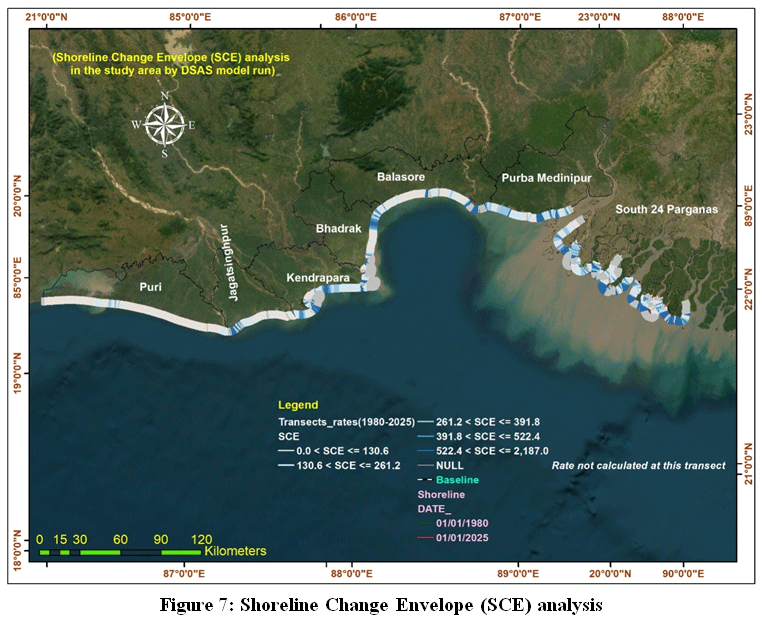 | Figure 7: Shoreline Change Envelope (SCE) analysis
|
Discussion
The analysis of shoreline dynamics over the 45-year study period (1980–2025) reveals significant spatial heterogeneity in erosion and accretion patterns across the Odisha and West Bengal coasts. Unlike a purely descriptive approach, these findings must be interpreted through the lens of regional geomorphic processes and climatic drivers.The assessment of shoreline change must account for the inherent uncertainties in remote sensing data. To ensure the statistical robustness of our findings, we computed the uncertainty budget (Ut). This rigorous process verified that the observed erosional and accretional trends (EPR and NSM) are geomorphologically significant rather than artifacts of spatial resolution constraints or tidal fluctuations. This quantitative approach strengthens the reliability of our findings, especially in highly dynamic areas like the Sundarbans.
Comparative Analysis with Previous Studies
The extreme erosion recorded in the South 24 Parganas (maximum NSM of -2186.94 m) aligns with the findings of Hazra et al. (2002), who documented rapid land loss in the Sundarbans delta due to high relative sea-level rise and lack of sediment supply. Our results are also consistent with the recent assessment by Sreeraj et al. (2022), which highlighted that the northern Bay of Bengal is experiencing one of the highest rates of shoreline retreat globally. While localized accretion was observed in some pockets of Odisha (e.g., Balasore), the overall trend in the deltaic West Bengal remains predominantly erosional, echoing the "deltaic decay" theory discussed in prior literature.
Causative Factors: Cyclones and Sea-Level Rise
The intensified erosion in districts like South 24 Parganas and Purba Medinipur cannot be isolated from the increasing frequency of high-intensity tropical cyclones in the Bay of Bengal. Significant shoreline shifts were observed following major events such as Cyclone Amphan (2020) and Cyclone YAAS (2021). These storms brought massive storm surges that breached embankments and accelerated the inland migration of the shoreline.
Furthermore, the regional sea-level rise (SLR) in the Bengal Delta is estimated to be higher than the global average due to land subsidence. This SLR, combined with the decreased sediment discharge from the dammed upstream rivers, creates a "sediment deficit" that prevents the delta from keeping pace with the rising sea. The loss of mangrove fringes, which otherwise act as a natural buffer, has further exposed the coast to direct wave energy, justifying the "noisy parameters" or high variability observed in the DSAS transects near the Sundarbans.
Integration of Field Observations
Our field surveys confirmed that many areas identified as "high erosion zones" in the DSAS model are currently facing severe saltwater intrusion and loss of agricultural land. The correlation between satellite-derived EPR data and field-level evidence of collapsed coastal structures validates the reliability of our geospatial findings. The long-term shoreline analysis (1980–2025) reveals complex geomorphic shifts that are influenced by both natural stressors and human-induced changes. To ensure scientific rigor, the previous descriptive terms such as "noisy parameters" have been replaced with more precise terminology to better reflect the coastal dynamics.
Spatial Variability in the Sundarbans
The shoreline of the South 24 Parganas, particularly within the Sundarbans delta, exhibits high spatial variability. The frequent fluctuation in shoreline positions is not a result of "noisy parameters" but is primarily due to spectral confusion caused by dense mangrove vegetation and the complex intertidal network. Mangrove ecosystems serve as vital natural barriers; however, their ongoing degradation exacerbates regional vulnerability. Our analysis suggests that the observed erosional patterns are driven by a synergy of rising sea levels and intense tidal current energy, rather than isolated environmental factors.
Impact of Extreme Weather Events
The "substantial" and "extreme" erosion rates identified in the results are closely linked to the increased frequency of tropical cyclones in the Bay of Bengal. Events like Cyclone Amphan (2020) and Cyclone YAAS (2021) caused massive coastal retreat. This is further exacerbated by the land subsidence occurring in the Bengal Delta, which makes the relative sea-level rise much higher than the global average.
Anthropogenic Pressures
Beyond natural factors, the stability of the Odisha and West Bengal coasts is being compromised by human activities. The construction of dams upstream reduces sediment flow, while sand mining and unregulated coastal construction interfere with the natural sediment budget.
In this study, calculating the Uncertainty Value (Ut) is essential when utilizing the Digital Shoreline Analysis System (DSAS) to quantify shoreline changes. The total uncertainty accounts for both natural and anthropogenic stressors, such as tidal currents, wind-driven waves, and human interventions, alongside measurement precisions including digitization errors, image interpretation, and GPS inaccuracies. A critical component of this uncertainty factor is the potential volatility caused by seasonal and tidal water-level fluctuations, which can affect the horizontal position of the shoreline. Given these variables, sea-level rise and climate change represent the most significant risks to the vulnerable, low-lying populations in this coastal region.16 Furthermore, coastal hazards and disasters have significantly accelerated shoreline retreat and the loss of tidal wetlands along the northern Bay of Bengal. The persistent erosion of these wetlands has led to a massive loss of mangrove vegetation, which serves as a natural defensive barrier. This study provides a multi-dimensional perspective of the region through rigorous statistical applications and geospatial modelling.For the long-term conservation and sustainability of this sensitive coastal ecosystem, micro-level development planning is essential to mitigate disaster risks. The quantitative methodology employed in this study, leveraging advanced remote sensing techniques, establishes a robust scientific foundation for coastal management initiatives. By integrating End Point Rate (EPR) and Net Shoreline Movement (NSM) metrics, we have developed a comprehensive assessment of coastal evolution over a 45-year period, thereby supporting informed, data-driven strategies for future coastal zone planning.
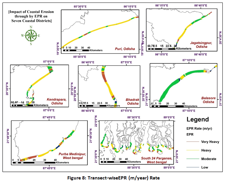 | Figure 8: Transect-wiseEPR (m/year) Rate
|
The study shows that the shoreline is rapidly changing along South 24 Parganas, Kendrapara, and Bhadrak districts in West Bengal and Odisha. But Puri, Jagatsingpur, Baleshwar, and Purba Medinipur coastal districts large coast are accretion in type. The study Investigates and views the significant changes in South 24 Parganas between 1980 and 2025. Interestingly, SCE reveals remarkable shift of shoreline, (Figure 8 & 9)which has estimated from the considered baseline, that helps the study significant.17
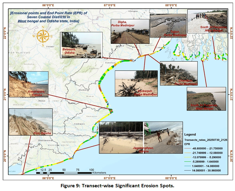 | Figure 9: Transect-wiseSignificant Erosion Spots.
|
Major Findings of the Study
Extreme Erosion in South 24 Parganas: This district recorded the most severe land loss, with a maximum Net Shoreline Movement (NSM) of -2186.94 m and an average End Point Rate (EPR) of -3.90 m/year.
Accretion in Balasore and Puri: Unlike the general erosional trend, these districts showed shoreline advancement, with Balasore recording a positive NSM of 43.25 m and an EPR of 0.96 m/year.
Regional Variability: The study highlights significant spatial heterogeneity; while South 24 Parganas, Kendrapara, and Bhadrak are rapidly eroding, districts like Puri and Jagatsinghpur remain relatively stable or show accretion.
Causative Factors: The rapid erosion in the West Bengal sector is attributed to high-energy storm surges from frequent cyclones (like Amphan and Yaas), sea-level rise, and a deficit in sediment supply.
Geospatial Accuracy: The use of the MNDWI index and Cohen’s Kappa assessment proved highly effective, achieving an overall classification accuracy of 97% for distinguishing land from water.
Deltaic Decay: The findings support the theory of "deltaic decay" in the Sundarbans region, where natural defenses like mangroves are being depleted, leaving the coast vulnerable to tidal energy.
Hotspot Identification: Critical erosion hotspots requiring urgent intervention were identified at Henry’s Island and Bakkhali in West Bengal, and Pentha Sea Beach in Odisha.
Coastal Management and Mitigation Strategies
The findings of this 45-year temporal analysis (1980–2025) reveal significant spatial heterogeneity in shoreline dynamics, necessitating a strategic and localized approach to coastal management. To safeguard the vulnerable ecosystems of Odisha and West Bengal, the following mitigation strategies are proposed:
Micro-level Development Planning: Given the extreme erosion identified in districts like South 24 Parganas (EPR: -3.90 m/year), authorities should implement localized development projects. These must address the specific geomorphological vulnerabilities of high-risk communities to effectively mitigate disaster risks at a granular level.
Nature-Based Defenses (NbS): Restoration and conservation of mangrove forests are critical, particularly in the Sundarbans and the Kendrapara district. As natural bio-shields, mangroves dissipate wave energy and stabilize intertidal mudflats, providing a vital defense against the frequent high-intensity tropical cyclones (e.g., Amphan and Yaas) observed in the Bay of Bengal.
Disaster-Resilient Infrastructure: Targeted structural interventions are required at identified erosion hotspots, such as Henry’s Island and Bakkhali in West Bengal, and Pentha Sea Beach in Odisha. The construction of disaster-resilient embankments and sea walls should be prioritized to protect human settlements from saltwater intrusion and land loss.
Sediment Budget Regulation: To counter the "sediment deficit" that prevents the delta from keeping pace with relative sea-level rise, systematic management of upstream dam activities is essential. Regulating unregulated sand mining and ensuring a steady supply of fluvial sediment are crucial for maintaining the morphological equilibrium of the shoreline.
Integrated Monitoring & Adaptive Planning: Leveraging advanced geospatial frameworks (DSAS and MNDWI) for continuous monitoring is fundamental. Future policy decisions must integrate long-term shoreline displacement data with adaptive planning that accounts for regional land subsidence and eustatic sea-level rise.
Community-Based Sustainable Livelihoods: Since nearly 70% of the population in vulnerable districts like South 24 Parganas depends on climate-sensitive farming and fishing, coastal management frameworks must incorporate socio-economic resilience programs to protect regional stability against the impacts of "deltaic decay".
Conclusion
This study presents a comprehensive 45-year (1984–2025) assessment of shoreline dynamics across seven coastal districts of West Bengal and Odisha using the Digital Shoreline Analysis System (DSAS). By integrating multi-temporal Landsat imagery and robust statistical metrics—including Net Shoreline Movement (NSM), End Point Rate (EPR), and Shoreline Change Envelope (SCE)—the research quantifies the long-term geomorphic shifts in the northern Bay of Bengal. The findings highlight that South 24 Parganas is the most vulnerable district, exhibiting the highest rates of coastal erosion with an average NSM of -175.57 m and an EPR of -3.90 m/year. This rapid land loss is driven by a combination of high-energy storm surges, mangrove depletion, and intense anthropogenic pressures. Given that nearly 70% of the district's 8.16 million residents (as per the 2011 Census) depend on climate-sensitive livelihoods like fishing and farming, this erosion poses a direct threat to regional socio-economic stability. In contrast, the Balasore district demonstrated a significant trend of accretion, with an NSM of 43.25 m and an EPR of 0.96 m/year, shifting the shoreline seaward. Other districts, such as Kendrapara and Bhadrak, also recorded notable erosion (average NSM of -84.1 m and EPR of -1.87 m/year), primarily due to frequent cyclonic activity and hydraulic wave action. Critical hotspots identified for urgent intervention include Henry’s Island and Bakkhali in West Bengal, and Pentha Sea Beach in Odisha. The study accounts for positional uncertainties, ensuring that the reported rates are statistically significant. These results provide a vital scientific foundation for coastal managers and policymakers. To mitigate future risks, it is recommended that authorities prioritize micro-level development projects, nature-based defenses such as mangrove restoration, and disaster-resilient infrastructure in these high-risk coastal communities.
Acknowledgement
The authors would like to express their sincere gratitude to the Principal and the administration of Egra S.S.B. College, Vidyasagar University, for providing the necessary facilities and a conducive research environment at the Coastal Environmental Studies Research Center. Special thanks are extended to the colleagues and staff of the Department of Geography for their constant encouragement and technical support throughout this study.
Funding Sources
The author(s) received no financial support for the research, authorship, and/or publication of this article.
Conflict of Interest
The authors do not have any conflict of interest.
Data Availability Statement
The manuscript incorporates all datasets produced or Investigated throughout this research study.
Ethics Statement
This research did not involve human participants, animal subjects, or any material that requires ethical approval.
Informed Consent Statement
This study did not involve human participants, and therefore, informed consent was not required.
Permission to reproduce material from other sources:
Not Applicable
Author Contributions
Mintu Jana: Conceptualization, Methodology, Data Collection, Formal Analysis, Visualization, Writing – Original Draft.
Dipak Bisai: Methodology, Validation, Supervision, Writing – Review & Editing.
References
- Ramachandran A, Sujatha M, Alruwais N, Alshahrani HM. Forecasting coastal stability: Digital shoreline analysis system and Geospatial Analysis techniques in evaluating impacts of cyclones. Reg Stud Mar Sci. 2024;81:103961. doi:10.1016/j.rsma.2024.103961
CrossRef - Pardo-Pascual JE, Almonacid-Caballer J, Ruiz LA, Palomar-Vázquez J. Assessing the accuracy of automated shoreline extraction from Landsat and Sentinel-2 imagery. Remote Sens. 2018;10(6):926. doi:10.3390/rs10060926
CrossRef - Christian E, Nwofor TNT, Ikebude CFI. Factors responsible for shoreline changes along Bonny and KAA shoreline, Rivers State. Int J Adv Eng Manag. 2025;7(7):556-564. doi:10.35629/5252-0707556564
CrossRef - Appeaning AK, Walkden M, Mills JP. Detection, measurement and prediction of shoreline recession in Accra, Ghana. ISPRS J Photogramm Remote Sens. 2008;63(5):543-558. doi:10.1016/j.isprsjprs.2008.02.001
CrossRef - Armenio E, De Serio F, Mossa M, Petrillo AF. Coastline evolution based on statistical analysis and modeling. Nat Hazards Earth Syst Sci. 2019;19(9):1937-1953. doi:10.5194/nhess-19-1937-2019
CrossRef - Pham LT, Le DK, Tong SS, Le HTT. Monitoring coastal erosion and deposition in Sam Son City, Vietnam – a contribution from remote sensing data. Inzynieria Mineralna. 2024;2(1). doi:10.29227/im-2024-01-96
CrossRef - Mansour N, Sarhan T, El-Gamal M, Nassar K. Assessing the compatibility of EPR (m/year) rates with one-dimensional numerical modelling in monitoring shoreline kinematics along with supplying near/long-term forecasts. Reg Stud Mar Sci. 2024;71:103391. doi:10.1016/j.rsma.2024.103391
CrossRef - Nayak GN, Noronha e D’Mello CA. Estuarine mudflat and mangrove sedimentary environments along central west coast of India. SF J Environ Earth Sci. 2018;1(1).
- Natesan U, Parthasarathy A. The potential impacts of sea level rise along the coastal zone of Kanyakumari District in Tamilnadu, India. J Coast Conserv. 2010;14(3):207-214. doi:10.1007/s11852-010-0103-6
CrossRef - Abd-Elhamid HF, Zelenáková M, Baranczuk J, Gergelova MB, Mahdy M. Historical trend analysis and forecasting of shoreline change at the Nile Delta using RS data and GIS with the DSAS tool. Remote Sens. 2023;15(7):1737. doi:10.3390/rs15071737
CrossRef - Freitas COA, De Carvalho JM, Oliveira J, Aires SBK, Sabourin R. Confusion matrix disagreement for multiple classifiers. Lect Notes Comput Sci. 2007:387-396. doi:10.1007/978-3-540-76725-1_41
CrossRef - Hazra S, Ghosh T, DasGupta R, Sen G. Sea level rise and its impact on Sunderban Islands, West Bengal, India. Indian J Mar Sci. 2002;31(1):25-31.
- Oyedotun TDT. Shoreline geometry: DSAS as a tool for historical trend analysis. In: Geomorphological Techniques. British Society for Geomorphology; 2014.
- Himmelstoss EA, Henderson RE, Kratzmann MG, Farris AS. Digital Shoreline Analysis System (DSAS) version 5.0 user guide. USGS Open-File Report; 2018.
CrossRef - Rahbani M, Ghaderi D. Long term investigation on shoreline changes of an island, inside a gulf (Hormuz Island). Reg Stud Mar Sci. 2024;71:103399. doi:10.1016/j.rsma.2024.103399
CrossRef - Huang S, Ramirez C, Kennedy K, et al. Updating land cover automatically based on change detection using satellite images: Case study of national forests in Southern California. GIScience Remote Sens. 2017;54(4):495-514. doi:10.1080/15481603.2017.1286727
CrossRef - Baig MRI, Ahmad IA, Shahfahad, Tayyab M, Rahman A. Analysis of shoreline changes in Vishakhapatnam coastal tract of Andhra Pradesh, India: An application of digital shoreline analysis system (DSAS). Ann GIS. 2020;26(4):361-376. doi:10.1080/19475683.2020.1815839
CrossRef